Home > Maps and Charts > Americas
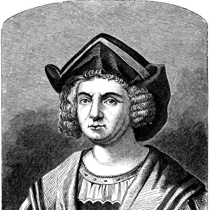
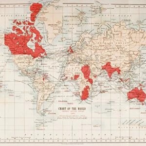
Map showing the routes of the four voyages of Christopher Columbus between 1492 and 1504. After an early 19th century work by Jean-Baptiste-Paul Touquet

![]()
Wall Art and Photo Gifts from Design Pics
Map showing the routes of the four voyages of Christopher Columbus between 1492 and 1504. After an early 19th century work by Jean-Baptiste-Paul Touquet
Design Pics offers Distinctively Different Imagery representing over 1,500 contributors
Media ID 24906429
© Ken Welsh
15th Century 16th Century Americas Caribbean Cartography Chart Exploration Explorer Geographical Geography Routes Voyages Cristobal Colon
FEATURES IN THESE COLLECTIONS
> Maps and Charts
> Early Maps
EDITORS COMMENTS
This print showcases a meticulously detailed map depicting the routes of Christopher Columbus' four groundbreaking voyages between 1492 and 1504. Created by Jean-Baptiste-Paul Touquet in the early 19th century, this historical artwork offers a glimpse into the remarkable exploration undertaken by one of history's most renowned explorers. The map takes us on a visual journey through time, tracing Columbus' expeditions across the vast expanse of the Americas and Caribbean. It serves as a testament to his audacity and determination to navigate uncharted waters in search of new lands and treasures. With its intricate illustrations and precise cartography, this archival piece transports us back to an era when geography was still being discovered. The faded hues evoke a sense of nostalgia for the past, reminding us that these voyages took place during the vibrant years of the 15th and 16th centuries. As we study this map, we are reminded not only of Columbus' significant contributions but also of humanity's insatiable thirst for knowledge and exploration. It stands as a symbol of our collective curiosity about distant lands and our relentless pursuit to expand our understanding of the world. Ken Welsh's expertly captured photograph brings out every minute detail with clarity, allowing us to appreciate both its artistic beauty and historical significance. This image is an invaluable addition to any collection celebrating great explorers or serving as inspiration for those embarking on their own journeys into uncharted territories.
MADE IN THE USA
Safe Shipping with 30 Day Money Back Guarantee
FREE PERSONALISATION*
We are proud to offer a range of customisation features including Personalised Captions, Color Filters and Picture Zoom Tools
SECURE PAYMENTS
We happily accept a wide range of payment options so you can pay for the things you need in the way that is most convenient for you
* Options may vary by product and licensing agreement. Zoomed Pictures can be adjusted in the Cart.