Home > Europe > Czech Republic > Maps
Map showing the new frontiers of Central Europe following the removal of

![]()
Wall Art and Photo Gifts from Fine Art Finder
Map showing the new frontiers of Central Europe following the removal of
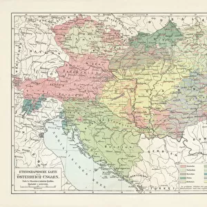
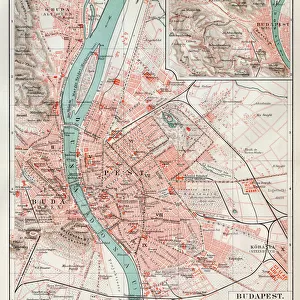
XEE4188271 Map showing the new frontiers of Central Europe following the removal of the Austro-Hungarian Empire (Austro-Hungarian) during the Treaty of Saint Germain en Laye: the First Czech Republic (Checoslovaca), Hungary and their coat of arms. Cover from " Le petit journal" from 14/03/1920 Private collection by Anonymous; Private Collection; (add.info.: Map showing the new frontiers of Central Europe following the removal of the Austro-Hungarian Empire (Austro-Hungarian) during the Treaty of Saint Germain en Laye: the First Czech Republic (Checoslovaca), Hungary and their coat of arms. Cover from " Le petit journal" from 14/03/1920 Private collection); Stefano Bianchetti; out of copyright
Media ID 23335144
© Stefano Bianchetti / Bridgeman Images
Blazon Coat Of Arm Czechoslovakia Hungarian Hungary A Journal Geographical Map
FEATURES IN THESE COLLECTIONS
> Europe
> Czech Republic
> Maps
> Europe
> Czech Republic
> Posters
> Europe
> Czech Republic
> Related Images
> Europe
> Hungary
> Related Images
> Fine Art Finder
> Artists
> Anonymous
> Maps and Charts
> Related Images
EDITORS COMMENTS
This print showcases a historical map depicting the new frontiers of Central Europe after the collapse of the Austro-Hungarian Empire during the Treaty of Saint Germain en Laye. The map highlights the emergence of the First Czech Republic (Checoslovaca) and Hungary, along with their respective coat of arms. Published in "Le petit journal" on March 14,1920, this cover from an anonymous private collection offers a fascinating glimpse into the geopolitical changes that took place during this pivotal period. The removal of the Austro-Hungarian Empire resulted in significant border realignments and reshaped European geography. The intricate engraving captures every detail with precision and artistry. Created by Stefano Bianchetti, an accomplished engraver whose work stands as a testament to his talent, this print is now part of a private collection. As we delve into history through this image, we are reminded of how political decisions can shape nations and redefine boundaries. This map serves as both an educational tool for understanding past events and a piece of artwork that reflects the skillful craftsmanship prevalent during that era. With its rich symbolism and historical significance, this print invites us to reflect upon Central Europe's transformation at such a crucial juncture in time. It reminds us that even amidst change and uncertainty, there is beauty to be found in maps – tangible representations capturing moments frozen forever within their borders.
MADE IN THE USA
Safe Shipping with 30 Day Money Back Guarantee
FREE PERSONALISATION*
We are proud to offer a range of customisation features including Personalised Captions, Color Filters and Picture Zoom Tools
SECURE PAYMENTS
We happily accept a wide range of payment options so you can pay for the things you need in the way that is most convenient for you
* Options may vary by product and licensing agreement. Zoomed Pictures can be adjusted in the Cart.