Home > Europe > France > Maps
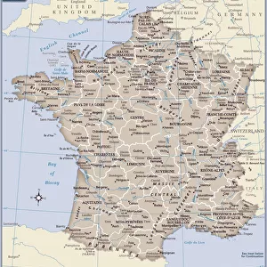
Map of France 1897

![]()
Wall Art and Photo Gifts from Fine Art Storehouse
Map of France 1897
Map of France 1897
Original edition from my own archives
Source : Brockhaus 1897
Unleash your creativity and transform your space into a visual masterpiece!
Grafissimo
Media ID 23793077
© Ralf Hettler
FEATURES IN THESE COLLECTIONS
> Fine Art Storehouse
> Map
> Historical Maps
> Maps and Charts
> Related Images
EDITORS COMMENTS
This print showcases a remarkable piece of history, the "Map of France 1897". With its original edition sourced from the prestigious Brockhaus in 1897, this exquisite archival find takes us on a journey back in time. The intricate details and precision displayed on this map are truly awe-inspiring. As we gaze upon this vintage masterpiece, we can't help but be transported to an era where cartography was both an art form and a scientific endeavor. Every contour, river, city, and border is meticulously depicted with utmost accuracy. It's as if we can almost hear the whispers of explorers who once relied on maps like these to navigate through the vast French landscape. The Map of France 1897 evokes a sense of nostalgia and curiosity about how much has changed since then. We ponder over historical events that have shaped this beautiful nation throughout the years. From bustling cities to serene countryside regions, every corner holds stories waiting to be discovered. Grafissimo's expert craftsmanship brings out the true essence of this rare gem by preserving its authenticity while presenting it in a visually stunning manner. This print serves as a testament to their dedication towards capturing history's most significant artifacts for all admirers to cherish. Whether you're an avid collector or simply appreciate fine art, having "Map of France 1897" adorning your walls will undoubtedly spark conversations and ignite wanderlust within you. Let yourself get lost in its intricate beauty while immersing yourself in the rich heritage that
MADE IN THE USA
Safe Shipping with 30 Day Money Back Guarantee
FREE PERSONALISATION*
We are proud to offer a range of customisation features including Personalised Captions, Color Filters and Picture Zoom Tools
SECURE PAYMENTS
We happily accept a wide range of payment options so you can pay for the things you need in the way that is most convenient for you
* Options may vary by product and licensing agreement. Zoomed Pictures can be adjusted in the Cart.