Home > Arts > Contemporary art > Digital artwork > Street art
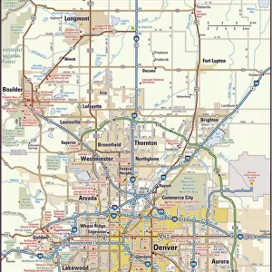
CT Fairfield Ridgefield Vector Road Map

![]()
Wall Art and Photo Gifts from Fine Art Storehouse
CT Fairfield Ridgefield Vector Road Map
CT Fairfield Ridgefield Vector Road Map. All source data is in the public domain. U.S. Census Bureau Census Tiger. Used Layers: areawater, linearwater, roads, rails, cousub, pointlm, uac10
Unleash your creativity and transform your space into a visual masterpiece!
Frank Ramspott
Media ID 20688169
© Frank Ramspott, all rights reserved
City Map Computer Graphic Connecticut County Digital Composite District Fairfield Geographical Border Road Map Text Vector Bethel Cedar Mountain Danbury Digitally Generated Image Fox Hill Pine Mountain Ridgefield
FEATURES IN THESE COLLECTIONS
> Animals
> Mammals
> Cats (Wild)
> Tiger
> Animals
> Mammals
> Muridae
> Water Mouse
> Arts
> Contemporary art
> Digital artwork
> Street art
> Arts
> Landscape paintings
> Waterfall and river artworks
> River artworks
> Arts
> Portraits
> Pop art gallery
> Street art portraits
> Arts
> Street art graffiti
> Digital art
> Digital paintings
> Fine Art Storehouse
> Map
> Reference Maps
> Maps and Charts
> Related Images
> Popular Themes
> Lake District
EDITORS COMMENTS
This print showcases the intricate details of the CT Fairfield Ridgefield Vector Road Map. Created by talented cartographer Frank Ramspott, this digitally generated image is a testament to his exceptional skills in design and map-making. The vibrant colors and precise lines bring this city map to life, highlighting the geographical borders, roads, rivers, and lakes that make up Fairfield County's charming towns. From the bustling city streets to serene bodies of water like Wataba Lake and Tuesdale Lake, every feature is meticulously depicted with utmost accuracy. As a result of utilizing public domain data from the U. S. Census Bureau Census Tiger database, Ramspott has created an authentic representation of Connecticut's physical geography. The inclusion of various layers such as areawater, linearwater, roads, rails, cousub (county subdivisions), pointlm (landmarks), and uac10 (urban areas) adds depth and richness to this visually stunning composition. With no people present in the image itself but rather focusing solely on the landscape and its features, viewers can immerse themselves in exploring each town's unique characteristics. Whether you're a resident or simply fascinated by cartography and digital composites alike, this remarkable artwork offers an opportunity for discovery within Connecticut's diverse landscapes.
MADE IN THE USA
Safe Shipping with 30 Day Money Back Guarantee
FREE PERSONALISATION*
We are proud to offer a range of customisation features including Personalised Captions, Color Filters and Picture Zoom Tools
SECURE PAYMENTS
We happily accept a wide range of payment options so you can pay for the things you need in the way that is most convenient for you
* Options may vary by product and licensing agreement. Zoomed Pictures can be adjusted in the Cart.