Home > Animals > Mammals > Muridae > Water Mouse
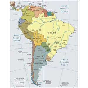
Green Map of Colombia - states, cities and flag

![]()
Wall Art and Photo Gifts from Fine Art Storehouse
Green Map of Colombia - states, cities and flag
Colombia, country of northwestern South America. Its 1, 000 miles (1, 600 km) of coast to the north are bathed by the waters of the Caribbean Sea, and its 800 miles (1, 300 km) of coast to the west are washed by the Pacific Ocean. The country is bordered by Panama, which divides the two bodies of water, on the northwest, by Venezuela and Brazil on the east, and by Peru and Ecuador on the south
Unleash your creativity and transform your space into a visual masterpiece!
Media ID 31661219
Colombia Flag Geographical Locations Global Global Positioning System Globe Navigational Equipment Land National Flag Navigational Equipment Separation Bogota Cartagena Colombia Colombian Flag
FEATURES IN THESE COLLECTIONS
> Animals
> Mammals
> Muridae
> Water Mouse
> Arts
> Artists
> O
> Oceanic Oceanic
> Europe
> France
> Canton
> Landes
> Fine Art Storehouse
> Map
> Reference Maps
> Maps and Charts
> Related Images
> North America
> Panama
> Maps
> North America
> Panama
> Panama City
> North America
> Panama
> Related Images
> South America
> Brazil
> Maps
> South America
> Brazil
> Related Images
EDITORS COMMENTS
This print showcases a vibrant Green Map of Colombia, offering a detailed depiction of its states, cities, and national flag. Colombia, located in northwestern South America, boasts an extensive coastline spanning 1,000 miles along the Caribbean Sea to the north and 800 miles washed by the Pacific Ocean to the west. The country shares borders with Panama on the northwest (separating these two bodies of water), Venezuela and Brazil on the east, and Peru and Ecuador on the south. The map highlights key geographical locations such as Bogota - the capital city - known for its rich history and cultural heritage. Additionally, Cartagena de Indias stands out as one of Colombia's most iconic cities with its stunning colonial architecture juxtaposed against modern developments. With no people visible in this illustration-style artwork produced using navigational equipment like globe positioning systems (GPS), it offers a comprehensive view of Colombia's diverse landscapes without any commercial connotations. This print serves as both an educational tool for geography enthusiasts or those interested in exploring Colombian culture while also adding a touch of sophistication to any space. Whether you are seeking inspiration or simply appreciate fine art prints that celebrate our world's beauty from Fine Art Storehouse collection – this Green Map of Colombia is sure to captivate your imagination.
MADE IN THE USA
Safe Shipping with 30 Day Money Back Guarantee
FREE PERSONALISATION*
We are proud to offer a range of customisation features including Personalised Captions, Color Filters and Picture Zoom Tools
SECURE PAYMENTS
We happily accept a wide range of payment options so you can pay for the things you need in the way that is most convenient for you
* Options may vary by product and licensing agreement. Zoomed Pictures can be adjusted in the Cart.