Home > Animals > Fishes > A > Atlantic Cod
MA Barnstable Harwich Vector Road Map

![]()
Wall Art and Photo Gifts from Fine Art Storehouse
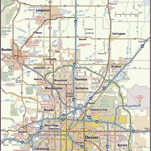
MA Barnstable Harwich Vector Road Map
MA Barnstable Harwich Vector Road Map. All source data is in the public domain. U.S. Census Bureau Census Tiger. Used Layers: areawater, linearwater, roads, rails, cousub, pointlm, uac10
Unleash your creativity and transform your space into a visual masterpiece!
Frank Ramspott
Media ID 20688429
© Frank Ramspott, all rights reserved
Atlantic Ocean Barnstable Cape Cod City Map Computer Graphic County Digital Composite District Geographical Border Harbor Massachusetts Road Map Text Vector Brewster Chatham Digitally Generated Image Harwich Nantucket Sound Pleasant Bay
FEATURES IN THESE COLLECTIONS
> Animals
> Fishes
> A
> Atlantic Cod
> Animals
> Mammals
> Cats (Wild)
> Tiger
> Animals
> Mammals
> Muridae
> Water Mouse
> Arts
> Artists
> O
> Oceanic Oceanic
> Arts
> Contemporary art
> Digital artwork
> Street art
> Arts
> Landscape paintings
> Waterfall and river artworks
> River artworks
> Arts
> Portraits
> Pop art gallery
> Street art portraits
> Arts
> Street art graffiti
> Digital art
> Digital paintings
> Fine Art Storehouse
> Map
> Reference Maps
> Maps and Charts
> Related Images
EDITORS COMMENTS
This print showcases the MA Barnstable Harwich Vector Road Map, a stunning piece of cartography art. Created by Frank Ramspott, this digitally generated image beautifully depicts the geographical features and intricate details of Massachusetts' Barnstable and Harwich areas. Using layers such as areawater, linearwater, roads, rails, cousub, pointlm, and uac10 from public domain data provided by the U. S. Census Bureau Census Tiger, Ramspott has masterfully designed a visually striking map that captures the essence of this region's physical geography. The color image is a digital composite that highlights various elements like cities, towns, rivers, lakes including Long Pond and Pleasant Lake, coastlines along Pleasant Bay and Cape Cod's harbor area. The map also portrays significant landmarks such as Brewster and Chatham while encompassing Nantucket Sound with its connection to the vast Atlantic Ocean. With no people present in this artwork focused on showcasing nature's beauty through computer graphics and vector design techniques; it offers viewers an opportunity to appreciate the intricacies of city maps without any distractions. Whether you're a fan of cartography or simply intrigued by Massachusetts' coastal charm depicted in this photo print; it serves as both an aesthetically pleasing decorative piece for your home or office space while providing valuable information about road networks within these regions.
MADE IN THE USA
Safe Shipping with 30 Day Money Back Guarantee
FREE PERSONALISATION*
We are proud to offer a range of customisation features including Personalised Captions, Color Filters and Picture Zoom Tools
SECURE PAYMENTS
We happily accept a wide range of payment options so you can pay for the things you need in the way that is most convenient for you
* Options may vary by product and licensing agreement. Zoomed Pictures can be adjusted in the Cart.