Home > Aerial Photography > Related Images
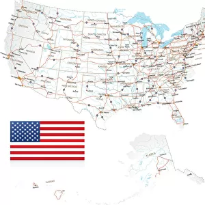
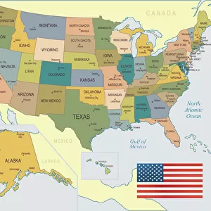
Grand Forks North Dakota US City Street Map

![]()
Wall Art and Photo Gifts from Fine Art Storehouse
Grand Forks North Dakota US City Street Map
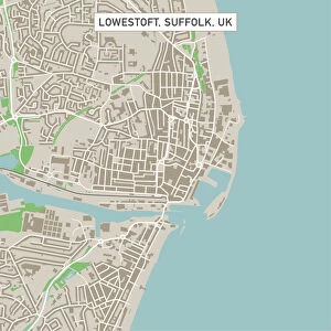
Vector Illustration of a City Street Map of Grand Forks, North Dakota, USA. Scale 1:60, 000.
All source data is in the public domain.
U.S. Geological Survey, US Topo
Used Layers:
USGS The National Map: National Hydrography Dataset (NHD)
USGS The National Map: National Transportation Dataset (NTD)
Unleash your creativity and transform your space into a visual masterpiece!
Frank Ramspott
Media ID 15215824
© Frank Ramspott, all rights reserved
Aerial View City Map Computer Graphic Directly Above Downtown District Gray North Dakota Road Map Text Digitally Generated Image Green Color Red River White Color
FEATURES IN THESE COLLECTIONS
> Aerial Photography
> Related Images
> Animals
> Insects
> Hemiptera
> Green Scale
> Arts
> Contemporary art
> Digital artwork
> Street art
> Arts
> Landscape paintings
> Waterfall and river artworks
> River artworks
> Arts
> Portraits
> Pop art gallery
> Street art portraits
> Arts
> Street art graffiti
> Digital art
> Digital paintings
> Arts
> Street art graffiti
> Digital art
> Vector illustrations
> Fine Art Storehouse
> Map
> Street Maps
> Fine Art Storehouse
> Map
> USA Maps
> Maps and Charts
> Geological Map
> Maps and Charts
> Related Images
> North America
> United States of America
> Lakes
> Related Images
EDITORS COMMENTS
This print showcases a meticulously detailed city street map of Grand Forks, North Dakota, USA. With a scale of 1:60,000, every intricate aspect of the city's layout is beautifully illustrated in this vector illustration. The image captures the essence of Grand Forks with its vibrant downtown district, meandering Red River, and picturesque lake. The map incorporates various layers sourced from the public domain including USGS The National Map: National Hydrography Dataset (NHD) and USGS The National Map: National Transportation Dataset (NTD). These layers provide accurate information about the hydrography and transportation network within the city. Designed by Frank Ramspott using computer graphics techniques, this digitally generated image presents an aerial view directly above Grand Forks. The color palette includes shades of gray, blue, white, and green to enhance visual clarity and readability. With no people depicted in the image itself, all attention is drawn towards exploring the physical geography and cartography that make up this remarkable cityscape. This print serves as both a functional road map for residents or visitors navigating through Grand Forks as well as an artistic representation celebrating its unique urban design
MADE IN THE USA
Safe Shipping with 30 Day Money Back Guarantee
FREE PERSONALISATION*
We are proud to offer a range of customisation features including Personalised Captions, Color Filters and Picture Zoom Tools
SECURE PAYMENTS
We happily accept a wide range of payment options so you can pay for the things you need in the way that is most convenient for you
* Options may vary by product and licensing agreement. Zoomed Pictures can be adjusted in the Cart.