Home > Europe > United Kingdom > England > London > Towns > Hornsey
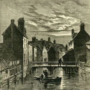
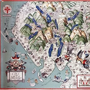
Map of Hornsey and Neighbourhood in 1819, (c1876). Creator: Unknown
. Creator: Unknown")
![]()
Wall Art and Photo Gifts from Heritage Images
Map of Hornsey and Neighbourhood in 1819, (c1876). Creator: Unknown
Map of Hornsey and Neighbourhood in 1819, (c1876).. The village grew dramatically after c1860. From " Old and New London: A Narrative of Its History, Its People, and Its Places. The Western and Northern Studies", by Edward Walford. [Cassell, Petter, Galpin & Co. London, Paris & New York]
Heritage Images features heritage image collections
Media ID 19124924
© The Print Collector/Heritage Images
Cassell Petter Galpin Cassell Petter Galpin Co Co Cassell Petter Galpin Edward Edward Walford Full Frame Galpin And Co Georgian Haringey London England United Kingdom Neighbourhood North London Old And New London Petter Petter And Galpin Urbanisation Walford Walford Edward Cassell Hornsey
FEATURES IN THESE COLLECTIONS
> Arts
> Artists
> D
> Edward Dayes
> Arts
> Minimalist artwork
> Monochrome artwork
> Fine art
> Arts
> Minimalist artwork
> Monochrome artwork
> Monochrome paintings
> Asia
> Georgia
> Related Images
> Europe
> France
> Paris
> Maps
> Europe
> United Kingdom
> England
> London
> Boroughs
> Haringey
> Europe
> United Kingdom
> England
> London
> Towns
> Hornsey
> Europe
> United Kingdom
> England
> Maps
> Europe
> United Kingdom
> England
> York
EDITORS COMMENTS
This print showcases a historical treasure, the "Map of Hornsey and Neighbourhood in 1819". Created by an unknown artist around 1876, this antique map offers a fascinating glimpse into the past. The village of Hornsey experienced remarkable growth during the mid-19th century, as depicted on this intricate engraving. From Edward Walford's renowned publication "Old and New London: A Narrative of Its History, Its People, and Its Places", this map reveals the evolution of Hornsey from a quaint countryside settlement to a bustling urban center. The monochrome image transports us back to Georgian England, capturing the essence of that era. Every detail is meticulously illustrated within this full-frame engraving - streets winding through the cityscape, landmarks dotting the landscape, and neighborhoods expanding with each passing year. This historic piece not only provides valuable insights into Hornsey's development but also serves as a testament to Britain's rich history. The significance of this map extends beyond its aesthetic appeal; it represents an important milestone in urbanization. As we gaze upon it today, we can appreciate how far our cities have come while cherishing their roots. Let this image transport you back in time to witness firsthand the transformation that shaped Hornsey into what it is today – a vibrant part of North London's tapestry.
MADE IN THE USA
Safe Shipping with 30 Day Money Back Guarantee
FREE PERSONALISATION*
We are proud to offer a range of customisation features including Personalised Captions, Color Filters and Picture Zoom Tools
SECURE PAYMENTS
We happily accept a wide range of payment options so you can pay for the things you need in the way that is most convenient for you
* Options may vary by product and licensing agreement. Zoomed Pictures can be adjusted in the Cart.