Home > Europe > France > Paris > Maps
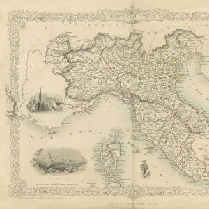
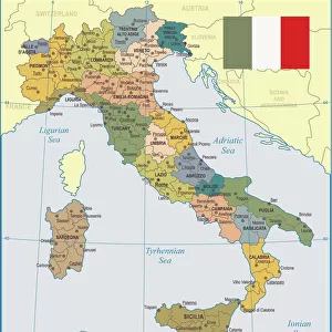
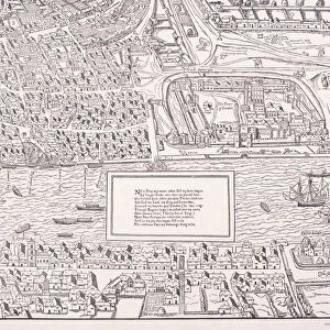
Map of Northern and Central Italy, 1890. Creator: Unknown

![]()
Wall Art and Photo Gifts from Heritage Images
Map of Northern and Central Italy, 1890. Creator: Unknown
Map of Northern and Central Italy, 1890. From " Cassells Illustrated Universal History Vol. II - Rome", by Edmund Ollier. [Cassell and Company, Limited, London, Paris and Melbourne, 1890]
Heritage Images features heritage image collections
Media ID 19126170
© The Print Collector/Heritage Images
Cartography Cassells Cassells Illustrated Universal History Co Cassell Coastline Edmund Edmund Ollier Map Making Ollier Ollier Edmund Western Script Cassell And Company Ltd
FEATURES IN THESE COLLECTIONS
> Arts
> Artists
> R
> Roman Roman
> Arts
> Literature
> Illustration
> Arts
> Literature
> Arts
> Minimalist artwork
> Monochrome artwork
> Fine art
> Arts
> Minimalist artwork
> Monochrome artwork
> Monochrome paintings
> Europe
> France
> Paris
> Maps
> Europe
> Italy
> Lazio
> Rome
> Maps and Charts
> Early Maps
> Maps and Charts
> Italy
EDITORS COMMENTS
This print showcases a Map of Northern and Central Italy, dating back to 1890. With its origins shrouded in mystery, the creator remains unknown, adding an air of intrigue to this historical artifact. The map is sourced from "Cassells Illustrated Universal History Vol. II - Rome" a renowned publication by Edmund Ollier. Transporting us back to the 19th century, this monochrome engraving offers a glimpse into ancient times, specifically Ancient Rome. Its intricate details depict the country's coastline with precision while highlighting key locations and landmarks along the way. As we explore this cartographic masterpiece, it becomes evident that it was crafted with meticulous attention to detail. The map's inclusion in Cassell and Company Limited's esteemed collection further solidifies its significance within literature and geography during that era. It serves as a testament to the artistry involved in map-making during the nineteenth century. While we may not know who precisely created this remarkable piece or how it came into existence, one thing is certain: it holds immense historic value. A fusion of art and history captured on paper, this print transports us through time as we unravel Italy's rich cultural heritage through Western script text accompanying the illustration. Preserved by The Print Collector for future generations to appreciate, this Map of Northern and Central Italy stands as a tangible link between our present-day world and centuries past – an invaluable treasure waiting to be explored anew.
MADE IN THE USA
Safe Shipping with 30 Day Money Back Guarantee
FREE PERSONALISATION*
We are proud to offer a range of customisation features including Personalised Captions, Color Filters and Picture Zoom Tools
SECURE PAYMENTS
We happily accept a wide range of payment options so you can pay for the things you need in the way that is most convenient for you
* Options may vary by product and licensing agreement. Zoomed Pictures can be adjusted in the Cart.