Home > Arts > Artists > W > Robert Walker
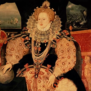
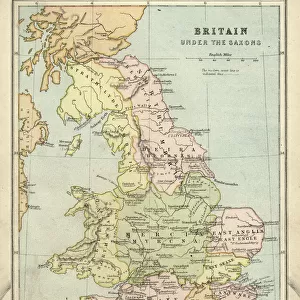
The World in the Elizabethan Era, 1926. Creators: Unknown, Emery Walker Ltd

![]()
Wall Art and Photo Gifts from Heritage Images
The World in the Elizabethan Era, 1926. Creators: Unknown, Emery Walker Ltd
The World in the Elizabethan Era, 1926. Map of the world during the reign of Queen Elizabeth I (1558-1603). The key shows: Mediaeval Trade routes, (the shipping in Asiatic seas was oriental). Portuguese and Spanish settlements. The dotted line from Greenland down through eastern Brazil represents the Popes division of the globe between Spain and Portugal, 1494. Also marked are the voyages of Francis Drake, Vasco da Gama and Christopher Columbus. Many parts of the world remained unknown at that period. From " History of England", by George Macaulay Trevelyan. [Longmans, Green and Co. Ltd, London, 1926]
Heritage Images features heritage image collections
Media ID 19044916
© The Print Collector/Heritage Images
Boutall Cartography Christopher Christopher Columbus Cockerell Colonisation Columbus Cristobal Colon Dom Vasco Da Gama Drake Elizabethan Emery Emery Walker Limited Emery Walker Ltd Francis Francis Drake Francisco Drake Gama Green And Co History Of England Imperial Imperialism Longman Longman And Co Longmans Map Making Roberts And Green Shipping Route Sir Francis Sir Francis Drake Tartary The Unknown Trade Route Trevelyan Vasco Da Vasco Da Gama Walker Walker And Walker And Boutall Walker And Cockerell World Hindoostan
FEATURES IN THESE COLLECTIONS
> Arts
> Artists
> D
> Francis Drake
> Arts
> Artists
> W
> Robert Walker
> Arts
> Literature
> Asia
> India
> Related Images
> Europe
> Portugal
> Related Images
> Europe
> United Kingdom
> England
> Maps
EDITORS COMMENTS
This print titled "The World in the Elizabethan Era, 1926" takes us back to a time of exploration and discovery. Created by unknown artists and Emery Walker Ltd, this map showcases the world during Queen Elizabeth I's reign from 1558 to 1603. The intricate details on this map provide a glimpse into the historical context of that era. The key highlights various elements such as medieval trade routes, emphasizing the oriental shipping in Asiatic seas. It also marks Portuguese and Spanish settlements, showcasing their colonial influence across different regions. One notable feature is the dotted line stretching from Greenland down through eastern Brazil, representing the Pope's division of the globe between Spain and Portugal in 1494. This division played a significant role in shaping future explorations and colonization efforts. Additionally, this map includes markings indicating famous voyages undertaken by renowned explorers like Francis Drake, Vasco da Gama, and Christopher Columbus. These brave individuals expanded horizons and paved new paths for future generations. It is important to note that during this period many parts of the world remained unknown or unexplored territory - represented here as terra incognita or "the unknown". This serves as a reminder of how limited knowledge was at that time compared to our modern understanding. Overall, this print offers an intriguing insight into both cartography and history during one of England's most iconic eras - an era characterized by exploration, imperial ambitions, cultural exchange, and global transformation.
MADE IN THE USA
Safe Shipping with 30 Day Money Back Guarantee
FREE PERSONALISATION*
We are proud to offer a range of customisation features including Personalised Captions, Color Filters and Picture Zoom Tools
SECURE PAYMENTS
We happily accept a wide range of payment options so you can pay for the things you need in the way that is most convenient for you
* Options may vary by product and licensing agreement. Zoomed Pictures can be adjusted in the Cart.