Home > Europe > United Kingdom > England > London > Boroughs > Harrow
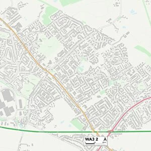
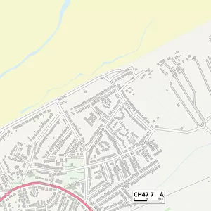
Wirral CH44 2 Map

![]()
Wall Art and Photo Gifts from Map Marketing
Wirral CH44 2 Map
Postcode Sector Map of Wirral CH44 2
Media ID 19968260
Beaufort Drive Beechwood Avenue Buckingham Road Ch44 Church Hill Colville Road Folly Lane Harrow Close Harrow Road Hillside Road Neville Road Pennine Road Radley Road Radstock Road Rugby Road Russell Road School Lane Sherborne Road Shrewsbury Road Stonehouse Road Uppingham Road Westbourne Road Winchester Drive Wirral
FEATURES IN THESE COLLECTIONS
> Europe
> United Kingdom
> England
> London
> Boroughs
> Harrow
> Europe
> United Kingdom
> Scotland
> Highlands
> Cromarty
> Map Marketing
> Postcode Sector Maps
> CH - Chester
> Maps and Charts
> Related Images
MADE IN THE USA
Safe Shipping with 30 Day Money Back Guarantee
FREE PERSONALISATION*
We are proud to offer a range of customisation features including Personalised Captions, Color Filters and Picture Zoom Tools
SECURE PAYMENTS
We happily accept a wide range of payment options so you can pay for the things you need in the way that is most convenient for you
* Options may vary by product and licensing agreement. Zoomed Pictures can be adjusted in the Cart.