Home > Europe > United Kingdom > Wales > Pembrokeshire > Milford Haven
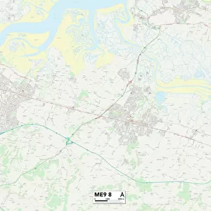
Maidstone ME17 3 Map

![]()
Wall Art and Photo Gifts from Map Marketing
Maidstone ME17 3 Map
Postcode Sector Map of Maidstone ME17 3
Media ID 19974876
Ashford Drive Baker Lane Broad Street Broomfield Road Chapel Road Charlton Lane Chestnut Drive Church Lane Church Road Copperfield Close Elder Close Forge Lane Friday Street Green Lane Haven Close Headcorn Road Heath Road Heathfield High Street Ivy Close Kingswood Langley Laurel Grove Leeds Road Lower Farm Road Lower Road Maidstone Maidstone Road New Road North Street Norton Road Orchard Close Pitt Road Rectory Lane Reynolds Avenue School Lane Shepherds Close Shepherds Way South Bank South Lane Sutton Road Tall Trees Close The Brambles The Oaks West Drive West View Whitehall Drive Wildwood Close Workhouse Lane Forsters Grasslands The Harbour
FEATURES IN THESE COLLECTIONS
> Animals
> Birds
> Passerines
> Finches
> Brambling
> Animals
> Mammals
> Muridae
> Heath Mouse
> Europe
> United Kingdom
> Wales
> Pembrokeshire
> Milford Haven
> Map Marketing
> Postcode Sector Maps
> ME - Rochester
> Maps and Charts
> Related Images
MADE IN THE USA
Safe Shipping with 30 Day Money Back Guarantee
FREE PERSONALISATION*
We are proud to offer a range of customisation features including Personalised Captions, Color Filters and Picture Zoom Tools
SECURE PAYMENTS
We happily accept a wide range of payment options so you can pay for the things you need in the way that is most convenient for you
* Options may vary by product and licensing agreement. Zoomed Pictures can be adjusted in the Cart.