Home > Arts > Artists > S > John Speed
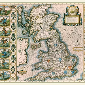
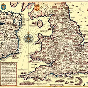
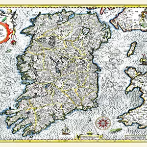
Old Map of The Invasions of England and Ireland by John Speed

![]()
Wall Art and Photo Gifts from MapSeeker
Old Map of The Invasions of England and Ireland by John Speed
A facimile of John Speeds historical map of the Invasions of England and Ireland originally published for the " Theatre of the Empire of Great Britain", an atlas to accompany " a history of Great Britain"
Welcome to the Mapseeker Image library and enter an historic gateway to one of the largest on-line collections of Historic Maps, Nostalgic Views, Vista's and Panorama's from a World gone by.
Media ID 20347973
© Mapseeker Publishing Ltd
Historic Map John Speed Map Speed Map Speede Map
FEATURES IN THESE COLLECTIONS
> Arts
> Artists
> S
> John Speed
> Europe
> Republic of Ireland
> Maps
> Europe
> United Kingdom
> England
> Maps
> Maps and Charts
> British Empire Maps
> Maps and Charts
> Early Maps
> MapSeeker
> Maps from the British Isles
> British Isles Map PORTFOLIO
> MapSeeker
> Maps from the British Isles
> England with Wales PORTFOLIO
> MapSeeker
> Maps from the British Isles
> Ireland and Provinces PORTFOLIO
EDITORS COMMENTS
This print showcases an exquisite facsimile of John Speed's historical map titled "Old Map of The Invasions of England and Ireland". Originally published for the renowned "Theatre of the Empire of Great Britain" this map serves as a remarkable companion to the comprehensive narrative that chronicles the history of Great Britain. With intricate details and meticulous craftsmanship, this old map offers a fascinating glimpse into the invasions that have shaped both England and Ireland throughout centuries. It unravels a tapestry woven with tales of conquests, struggles, and cultural exchanges. As we delve into its rich cartographic depiction, we are transported back in time to witness pivotal moments in British history. From Viking raids on English shores to Norman invasions that forever altered the course of these lands, every invasion is meticulously marked upon this historic treasure. Notably attributed to John Speed, a celebrated cartographer from yesteryears, this map stands as a testament to his exceptional skill and dedication. Its aged appearance adds an air of authenticity and reverence for those who appreciate historical artifacts. Whether you are an avid historian or simply captivated by maps' allure, this print invites you on an enchanting journey through time. Explore the intricacies within each stroke as you immerse yourself in the story told by lines drawn centuries ago—a true masterpiece capturing the essence of ancient battles etched onto paper for generations to admire.
MADE IN THE USA
Safe Shipping with 30 Day Money Back Guarantee
FREE PERSONALISATION*
We are proud to offer a range of customisation features including Personalised Captions, Color Filters and Picture Zoom Tools
SECURE PAYMENTS
We happily accept a wide range of payment options so you can pay for the things you need in the way that is most convenient for you
* Options may vary by product and licensing agreement. Zoomed Pictures can be adjusted in the Cart.