Home > Arts > Artists > B > James Bayes
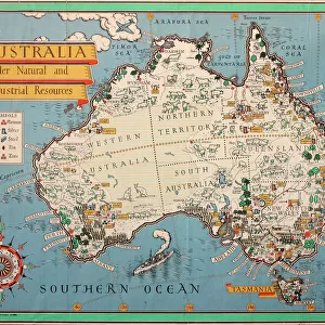
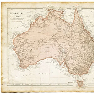
First circumnavigation of Australia by seaplane - 1924

![]()
Wall Art and Photo Gifts from Mary Evans Picture Library
First circumnavigation of Australia by seaplane - 1924
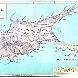
A map showing the route of the first circumnavigation of Australia by seaplane in 1924. On April 6, 1924, RAAF pilots Wing Commander Stanley James (Jimmy) Goble (1891-1948) and Flight Commander Ivor MacIntyre (1899-1928) took off from Point Cook, Victoria and flew anti-clockwise for 44 days. Their flight log recorded a distance of 8450 land miles covered in 93 hours. Official records only recorded 8200 miles in 90 hours, the discrepancy caused by wind and other natural factors and the route not being strictly "as the crow flies" between each stop. The aircraft used was a Fairey 111D Seaplane (floatplane)
Mary Evans Picture Library makes available wonderful images created for people to enjoy over the centuries
Media ID 14146153
© Mary Evans Picture Library/Onslow Auctions Limited
Albany Brisbane Broome Carnarvon Continent Darwin Elcho Israelite Lincoln Melbourne Onslow Perth Pioneering Pioneers Point Route Samson Seaplane Sydney Thursday Townsville Trip 1924 Geraldton
FEATURES IN THESE COLLECTIONS
> Animals
> Birds
> Passerines
> Crows And Jays
> Related Images
> Arts
> Artists
> B
> James Bayes
> Europe
> France
> Canton
> Landes
> Maps and Charts
> Early Maps
> Maps and Charts
> Related Images
> Oceania
> Australia
> Brisbane
> Oceania
> Australia
> Melbourne
EDITORS COMMENTS
This historic map depicts the groundbreaking route taken by RAAF (Royal Australian Air Force) pilots Wing Commander Stanley James "Jimmy" Goble and Flight Commander Ivor MacIntyre during the first circumnavigation of Australia by seaplane in 1924. On April 6, 1924, they took off from Point Cook, Victoria, embarking on an anti-clockwise journey around the Australian continent. Their flight lasted 44 days and covered a recorded distance of 8450 land miles in 93 hours. However, official records only document 8200 miles in 90 hours, with the discrepancy attributed to natural factors such as wind and the route not being a direct line between each stop. The intrepid aviators flew a Fairey 111D Seaplane, also known as a floatplane, which allowed them to take off and land on water. Their epic journey began at Point Cook, Victoria, and took them to various towns and ports along the coast, including Israelite Bay, Port Lincoln, Melbourne, Sydney, Brisbane, Townsville, Cooktown, Thursday Island, Elcho, Darwin, Broome, Point Samson, Onslow, Carnarvon, and Geraldton. They eventually returned to Perth and completed their circuit at Albany. This pioneering achievement in Australian aviation history marked a significant milestone in the exploration and mapping of the vast Australian continent. The 1920s, known as the 'roaring twenties,' was a time of innovation and adventure, and this flight embodied the spirit of exploration and the determination to push the boundaries of what was possible. This map serves as a testament to the courage and ingenuity of Goble and MacIntyre, whose legacy continues to inspire aviators and adventurers alike.
MADE IN THE USA
Safe Shipping with 30 Day Money Back Guarantee
FREE PERSONALISATION*
We are proud to offer a range of customisation features including Personalised Captions, Color Filters and Picture Zoom Tools
SECURE PAYMENTS
We happily accept a wide range of payment options so you can pay for the things you need in the way that is most convenient for you
* Options may vary by product and licensing agreement. Zoomed Pictures can be adjusted in the Cart.