Home > Europe > Italy > Lazio > Civitavecchia
Transporting the Montecitorio Obelisk

![]()
Wall Art and Photo Gifts from Science Photo Library
Transporting the Montecitorio Obelisk
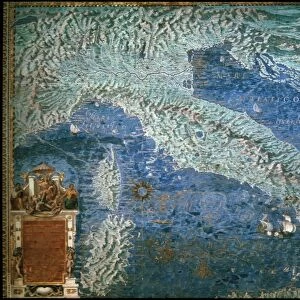
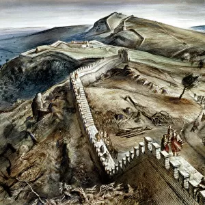
Roman Cargo Ship, reconstructed in the form of a raft, being used to transport the Montecitorio obelisk from Egypt to Rome in 10 BC. This obelisk is an ancient Egyptian, red granite obelisk of Psammetichus II (595-589 BC) from Heliopolis. Augustus erected it as the gnomon of the Solarium Augusti, his giant sundial, in the Campus Martius, Rome. It is now in the Piazza Montecitorio. Detail from a map of Civitavecchia in the Gallery of Maps in the Vatican Museum. These maps were commissioned between 1578 and 1580 to show the regions of Italy and territories of the church. They are based on the work of Ignazio Danti, a 16th century Italian priest, mathematician, astronomer and cosmographer, and are an important record of 16th century geography
Science Photo Library features Science and Medical images including photos and illustrations
Media ID 6320783
© Sheila Terry
1500s 16th Century Ancient Egypt Augustus Earth Science Gallery Of Maps Gnomon Ignazio Danti Italian Italy Rome Sciences Civitavecchia
FEATURES IN THESE COLLECTIONS
> Africa
> Egypt
> Related Images
> Arts
> Artists
> R
> Roman Roman
> Europe
> Italy
> Lazio
> Civitavecchia
> Europe
> Italy
> Lazio
> Rome
> Europe
> Italy
> Related Images
> Maps and Charts
> Early Maps
> Maps and Charts
> Italy
> Maps and Charts
> Related Images
EDITORS COMMENTS
This print showcases the remarkable feat of transporting the Montecitorio Obelisk, an ancient Egyptian artifact, from Egypt to Rome in 10 BC. The image depicts a reconstructed Roman cargo ship fashioned into a raft, specifically designed for this monumental task. The obelisk itself is a magnificent red granite structure dating back to the reign of Psammetichus II in Heliopolis. Commissioned by Augustus, the obelisk was erected as the gnomon of the Solarium Augusti, serving as a colossal sundial in Rome's Campus Martius. Today, it proudly stands in Piazza Montecitorio. This detailed snapshot is taken from one of Ignazio Danti's maps displayed at the Vatican Museum's Gallery of Maps. Created between 1578 and 1580 under papal patronage, these maps were intended to showcase Italy's regions and territories belonging to the Church. Ignazio Danti himself was not only an esteemed Italian priest but also excelled as a mathematician, astronomer, and cosmographer during the 16th century. Consequently, his cartographic works serve as invaluable records documenting geography during that era. Transporting such an immense historical treasure across vast distances reflects both Italy's rich heritage and its dedication to preserving ancient wonders. This photograph encapsulates centuries-old connections between civilizations while celebrating scientific advancements made possible through disciplines like astronomy and earth science.
MADE IN THE USA
Safe Shipping with 30 Day Money Back Guarantee
FREE PERSONALISATION*
We are proud to offer a range of customisation features including Personalised Captions, Color Filters and Picture Zoom Tools
SECURE PAYMENTS
We happily accept a wide range of payment options so you can pay for the things you need in the way that is most convenient for you
* Options may vary by product and licensing agreement. Zoomed Pictures can be adjusted in the Cart.