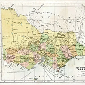
Victoria, Australia

![]()
Wall Art and Photo Gifts from Science Photo Library
Victoria, Australia
Victoria, Australia. True colour satellite image showing the state of Victoria, Australia, with the surrounding states and territories shaded out, and the Great Australian Bight (blue) at bottom. Australia comprises six states: New South Wales, Queensland, South Australia, Tasmania, Victoria, and Western Australia; and two major mainland territories: the Northern Territory and the Australian Capital Territory. Image compiled from data acquired by the LANDSAT 5 and 7 satellites, in 2000. Images highlighting all other regions of this country are available. For further information please contact SPL
Science Photo Library features Science and Medical images including photos and illustrations
Media ID 9212933
© PLANETOBSERVER/SCIENCE PHOTO LIBRARY
2000 Australia Australian Birds Eye View Cartography Cloudless Continent Country Earth Observation Environmental From Above From Space Indian Ocean Islands Land Landsat 5 Landsat 7 Natural Colour New South Wales Northern Territory Pacific Ocean Queensland Satellite Satellite Image South Australia Southern Hemisphere State States Territories Topographic Topography Victoria Western Australia Down Under Great Australian Bight
EDITORS COMMENTS
This print showcases the stunning state of Victoria, Australia, in all its true colors. The satellite image provides a bird's eye view of Victoria, with the surrounding states and territories shaded out to emphasize its unique beauty. At the bottom of the image lies the mesmerizing Great Australian Bight, depicted in a striking shade of blue. Australia itself is composed of six states: New South Wales, Queensland, South Australia, Tasmania, Victoria, and Western Australia; along with two major mainland territories: the Northern Territory and the Australian Capital Territory. This comprehensive image was compiled using data acquired by both LANDSAT 5 and 7 satellites back in 2000. The photo not only highlights Victoria's diverse topography but also offers a glimpse into other regions across this vast country. From coastlines bordering both the Pacific Ocean and Indian Ocean to intricate details captured from above – this picture truly encapsulates Australia's natural wonders. As we delve into this remarkable snapshot taken during Earth observation in the 21st century, it becomes evident that Victoria holds an extraordinary place within Australia's southern hemisphere landscape. With its rich lands and environmental treasures awaiting exploration, this image serves as a testament to Victoria's allure. For more information about this photograph or images showcasing other parts of Australia's magnificent geography, please contact Science Photo Library - your gateway to appreciating our planet from space.
MADE IN THE USA
Safe Shipping with 30 Day Money Back Guarantee
FREE PERSONALISATION*
We are proud to offer a range of customisation features including Personalised Captions, Color Filters and Picture Zoom Tools
SECURE PAYMENTS
We happily accept a wide range of payment options so you can pay for the things you need in the way that is most convenient for you
* Options may vary by product and licensing agreement. Zoomed Pictures can be adjusted in the Cart.