Home > Europe > United Kingdom > England > Sussex > Donnington
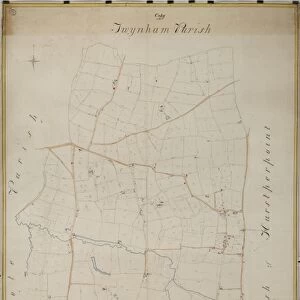
Donnington tithe map, 1839

![]()
Wall Art and Photo Gifts from West Sussex County Council
Donnington tithe map, 1839
By E. Fuller, Chichester. 26.6 in. to 1m. 73 × 31
Tithe Award Map Collection
West Sussex Record Office Ref No: TD/W40
West Sussex County Council Record Office contains a fascinating history of the county of West Sussex, England
Media ID 10702286
© West Sussex County Council - All Rights Reserved
1830s 19th Century Historical Mapping South Of England
FEATURES IN THESE COLLECTIONS
> Europe
> United Kingdom
> England
> Chichester
> Europe
> United Kingdom
> England
> Ely
> Europe
> United Kingdom
> England
> Maps
> Europe
> United Kingdom
> England
> Sussex
> Chichester
> Europe
> United Kingdom
> England
> Sussex
> Donnington
> Europe
> United Kingdom
> England
> Sussex
> Related Images
> Europe
> United Kingdom
> England
> West Sussex
> Chichester
> Europe
> United Kingdom
> England
> West Sussex
> Related Images
> Maps and Charts
> Early Maps
> Maps and Charts
> Related Images
> West Sussex County Council
> West Sussex Record Office
> Tithe Award Maps, 1808-1859
EDITORS COMMENTS
This print showcases the Donnington tithe map, a remarkable piece of historical mapping from 1839. Created by E. Fuller of Chichester, this meticulously detailed map offers a fascinating glimpse into the past and provides invaluable insights into land ownership and usage during the 19th century in southern England. Measuring an impressive 26.6 inches to one meter, this particular print is a testament to the craftsmanship and dedication that went into its creation. Preserved within the Tithe Award Map Collection at West Sussex Record Office, it stands as a valuable resource for researchers, historians, and anyone with an interest in local history. The Donnington tithe map not only serves as a visual representation of the landscape but also sheds light on social structures and economic practices prevalent at that time. It reveals intricate details about boundaries, fields, farms, roads, buildings, and other landmarks that have shaped the area's development over centuries. As part of West Sussex County Council's efforts to preserve our rich heritage for future generations to explore and learn from, this print holds immense significance. Its availability allows individuals to delve deep into their roots or study changes in land use patterns over time. While commercial use is not permitted for this image due to copyright restrictions associated with its ownership by West Sussex County Council (Ref No: TD/W40), it remains an invaluable resource for educational purposes or personal enjoyment alike.
MADE IN THE USA
Safe Shipping with 30 Day Money Back Guarantee
FREE PERSONALISATION*
We are proud to offer a range of customisation features including Personalised Captions, Color Filters and Picture Zoom Tools
SECURE PAYMENTS
We happily accept a wide range of payment options so you can pay for the things you need in the way that is most convenient for you
* Options may vary by product and licensing agreement. Zoomed Pictures can be adjusted in the Cart.