Home > Arts > Artists > O > Oceanic Oceanic
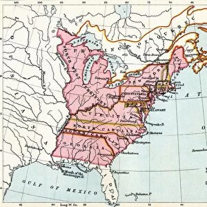
Map of the Colonies of North America at the time of the Declaration of Independence

![]()
Wall Art and Photo Gifts from Fine Art Finder
Map of the Colonies of North America at the time of the Declaration of Independence
PNP316579 Map of the Colonies of North America at the time of the Declaration of Independence (colour engraving) by American School; Private Collection; (add.info.: The United States Declaration of Independence was a statement adopted by the Second Continental Congress on July 4, 1776, announcing that the thirteen American colonies then at war with Great Britain were now independent states; These colonies constituted: Province of New Hampshire, Province of Massachusetts Bay, Colony of Rhode Island, Conneticut Colony, Province of New York, Province of New Jersey, Province of Pennsylavania, Delaware Colony, Province of Maryland, Colony and Dominion of Virginia, Province of North Carolina, Province of South Carolina and Province of Georgia; ); Peter Newark American Pictures; American, out of copyright
Media ID 23179008
© Peter Newark American Pictures / Bridgeman Images
Atlantic Ocean Declaration Of Independence Usa East Coast Grid Mapping America Continent
FEATURES IN THESE COLLECTIONS
> Arts
> Artists
> O
> Oceanic Oceanic
> Asia
> East Timor
> Maps
> Asia
> East Timor
> Related Images
> Asia
> Georgia
> Related Images
> Europe
> United Kingdom
> England
> Hampshire
> Related Images
> Fine Art Finder
> Artists
> American School
> Fine Art Finder
> Artists
> School American
> Fine Art Finder
> Maps (celestial & Terrestrial)
> Maps and Charts
> Early Maps
> Maps and Charts
> Related Images
EDITORS COMMENTS
This print showcases the Map of the Colonies of North America at the time of the Declaration of Independence. Created by an American School, this color engraving provides a visual representation of the thirteen American colonies that declared their independence from Great Britain on July 4,1776. The map highlights each colony that constituted what would later become known as the United States. From New Hampshire to Georgia, it depicts Province after Province, showcasing their individuality and significance in shaping American history. The intricate details and precision in cartography allow viewers to trace the eastern coastline along the Atlantic Ocean while also observing various grid patterns across different regions. As we delve into this eighteenth-century masterpiece, we are transported back in time to witness a pivotal moment in history - when these colonies transformed into independent states. This print serves as a powerful reminder of our nation's roots and its journey towards freedom. With its historical significance and artistic allure, this engraving is not only a testament to America's past but also an embodiment of national pride. It symbolizes unity among diverse colonies striving for liberty and self-governance. Displayed within private collections today, this print continues to inspire awe and admiration for those who seek knowledge about America's early days. Its presence reminds us all that our country's foundation was built upon bravery, determination, and unwavering belief in democratic principles.
MADE IN THE USA
Safe Shipping with 30 Day Money Back Guarantee
FREE PERSONALISATION*
We are proud to offer a range of customisation features including Personalised Captions, Color Filters and Picture Zoom Tools
SECURE PAYMENTS
We happily accept a wide range of payment options so you can pay for the things you need in the way that is most convenient for you
* Options may vary by product and licensing agreement. Zoomed Pictures can be adjusted in the Cart.