Home > Europe > United Kingdom > England > London > Boroughs > Bromley
Derby DE22 1 Map

![]()
Wall Art and Photo Gifts from Map Marketing
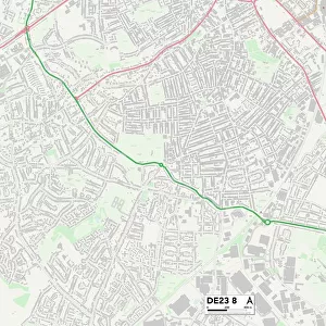
Derby DE22 1 Map
Postcode Sector Map of Derby DE22 1
Media ID 19969605
Abbey Lane Beech Drive Bradley Street Broadway Bromley Street Cedar Street Church Lane Coppice Close Darley Street Derby Duffield Road Folly Road Friars Close Highfield Gardens Highfield Road Longford Street Maxwell Avenue New Road North Avenue North Row Old Lane Park Grove Parker Street Poplar Row South Avenue Spinney Close Stanley Close The Hill Thistledown Close Walter Street Waterside Close West Park Road West Row White Street Willow Close Woodland Road Brick Row Cowley Street
FEATURES IN THESE COLLECTIONS
> Europe
> United Kingdom
> England
> London
> Boroughs
> Bromley
> Map Marketing
> Postcode Sector Maps
> DE - Derby
> Maps and Charts
> Related Images
MADE IN THE USA
Safe Shipping with 30 Day Money Back Guarantee
FREE PERSONALISATION*
We are proud to offer a range of customisation features including Personalised Captions, Color Filters and Picture Zoom Tools
SECURE PAYMENTS
We happily accept a wide range of payment options so you can pay for the things you need in the way that is most convenient for you
* Options may vary by product and licensing agreement. Zoomed Pictures can be adjusted in the Cart.