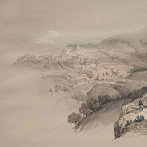
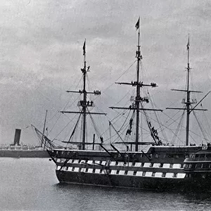
Home > Arts > Artists > S > Abraham Solomon
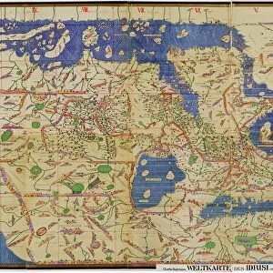
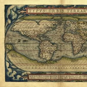
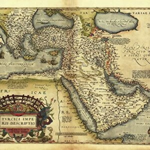
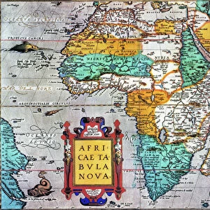
Orteliuss map of The New World, 1603

![]()
Wall Art and Photo Gifts from Science Photo Library
Orteliuss map of The New World, 1603
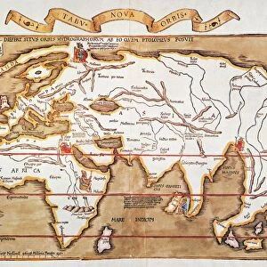
Orteliuss map of The New World. This map of the Americas is from the 1603 edition of Theatrum orbis terrarum (Theatre of the World). First published in 1570 by Flemish mapmaker Abraham Ortelius (1527-1598), this collection is considered to be the first true modern atlas. There were three versions of the Americae sive novi orbis, nova descriptio map: 1570, 1579, and 1587. This is the 1603 state of the 1587 version (date given in text at lower right). Several states were produced between 1587 and 1612. The cartouche at upper left refers to unknown northern regions. New discoveries include New Guinea and the Solomon Islands (far left)
Science Photo Library features Science and Medical images including photos and illustrations
Media ID 9209773
© MIDDLE TEMPLE LIBRARY/SCIENCE PHOTO LIBRARY
1500s 1600s 16th Century 17th Century Abraham Ortelius Age Of Discovery Amazon America Americas Argentina Argentinian Atlantic Brazil Brazilian Canada Canadian Caribbean Cartography Chile Continent Continental Continents Dutch Empire Flemish French Imperial Latin America Maritime Mexican Mexico New Guinea New World North American Oceans Pacific Peru Peruvian Portuguese Rivers Ship Ships Solomon Islands South America South American Spanish State Theatre Of The World Theatrum Orbis Terrarum 1587 1603 Empires Incognito New France New Spain Pacific Islands Parana Rio De La Plata Terra Australis Uruguay
FEATURES IN THESE COLLECTIONS
> Animals
> Mammals
> Cricetidae
> Australis
> Animals
> Mammals
> Delphinidae
> Australis
> Animals
> Mammals
> Molossidae
> Australis
> Arts
> Artists
> O
> Abraham Ortelius
> Arts
> Artists
> O
> Oceanic Oceanic
> Arts
> Artists
> S
> Abraham Solomon
> Arts
> Landscape paintings
> Waterfall and river artworks
> River artworks
> Maps and Charts
> Abraham Ortelius
EDITORS COMMENTS
This print showcases Orteliuss map of The New World, dating back to 1603. Abraham Ortelius, a renowned Flemish mapmaker, first published this collection in 1570, making it the very first true modern atlas. The map displayed here is the 1603 state of the 1587 version and represents an important milestone in cartography. The map itself provides a fascinating glimpse into the geographical knowledge and discoveries of that era. It includes various regions such as European colonies like Brazil and Uruguay, as well as North American territories like Canada and Mexico. South America is also prominently featured with countries like Argentina, Chile, Peru, and Brazil clearly outlined. Notable additions to this edition are New Guinea and the Solomon Islands on the far left side of the map. These new discoveries highlight how explorers were constantly pushing boundaries during what is known as the Age of Discovery. The intricate details captured within this artwork transport us back to a time when maritime exploration was at its peak. Ships gracefully navigate through vast oceans while rivers meander across continents. This visual representation allows us to appreciate both historical context and geographical significance. Overall, this print serves as a testament to Abraham Ortelius's contribution to cartography and offers a window into our understanding of the world during one of history's most transformative periods.
MADE IN THE USA
Safe Shipping with 30 Day Money Back Guarantee
FREE PERSONALISATION*
We are proud to offer a range of customisation features including Personalised Captions, Color Filters and Picture Zoom Tools
SECURE PAYMENTS
We happily accept a wide range of payment options so you can pay for the things you need in the way that is most convenient for you
* Options may vary by product and licensing agreement. Zoomed Pictures can be adjusted in the Cart.