Home > Maps and Charts > Related Images
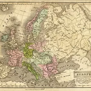
Map of the Baltic Sea (engraving)
")
![]()
Wall Art and Photo Gifts from Fine Art Finder
Map of the Baltic Sea (engraving)
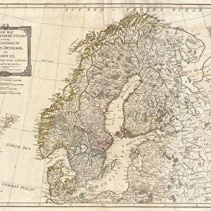
1619137 Map of the Baltic Sea (engraving) by Dower, John (fl.c.1845-55); Private Collection; (add.info.: Map of the Baltic Sea. Illustration for The Illustrated London News, 18 March 1854.
John Dower); Look and Learn / Illustrated Papers Collection
Media ID 22322098
© Look and Learn / Illustrated Papers Collection / Bridgeman Images
FEATURES IN THESE COLLECTIONS
> Fine Art Finder
> Artists
> English School
> Fine Art Finder
> Artists
> John Dower
> Maps and Charts
> Related Images
EDITORS COMMENTS
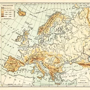
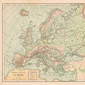
This print showcases a remarkable engraving titled "Map of the Baltic Sea" by John Dower, a talented artist who flourished between 1845 and 1855. The image is part of a private collection and was originally published in The Illustrated London News on March 18,1854. The map itself is an intricate representation of the Baltic Sea region, meticulously crafted with fine details that transport us back to the mid-19th century. It offers a glimpse into the historical significance of this vital waterway, which has long been a hub for trade, exploration, and cultural exchange. Dower's artistic prowess shines through in this piece as he masterfully captures every contour and coastline with precision. From Sweden to Finland, from Denmark to Russia, each country's borders are clearly defined while smaller islands dotting the sea add depth and intrigue. As we gaze upon this enchanting print, our imagination takes flight as we envision mighty ships sailing across these waters during an era when maritime adventures were at their peak. We can almost hear seagulls cry out overhead as sailors navigate treacherous currents or seek refuge within hidden coves along these shores. This print not only serves as a visual delight but also invites us to delve deeper into history and explore the rich tapestry woven by nations connected by the Baltic Sea. It reminds us of how art can transcend time and space, allowing us to appreciate both its aesthetic beauty and educational value for generations to come.
MADE IN THE USA
Safe Shipping with 30 Day Money Back Guarantee
FREE PERSONALISATION*
We are proud to offer a range of customisation features including Personalised Captions, Color Filters and Picture Zoom Tools
SECURE PAYMENTS
We happily accept a wide range of payment options so you can pay for the things you need in the way that is most convenient for you
* Options may vary by product and licensing agreement. Zoomed Pictures can be adjusted in the Cart.