Home > Maps and Charts > World
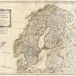
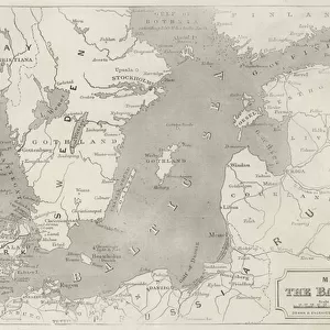
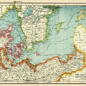
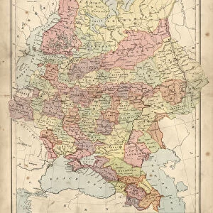
Baltic Countries, c1907, (1907)
")
![]()
Wall Art and Photo Gifts from Heritage Images
Baltic Countries, c1907, (1907)
Baltic Countries, c1907, (1907). A map of the Baltic Countries. From The Worlds History, Volume VI. Edited by Dr. H. F. Helmolt [William Heinemann, London, 1907]
Heritage Images features heritage image collections
Media ID 14970665
© The Print Collector
Baltic Baltic Sea Baltic States Cartography Dr H F Helmolt Dr Hf Helmolt H F Helmolt Hans F Hans F Hans Ferdinand Hans Ferdinand Hans Ferdinand Helmolt Heinemann Helmolt Hf Helmolt Map Making The Worlds History William Heinemann William Heinemann Ltd Wmheinemann World Titled
FEATURES IN THESE COLLECTIONS
> Arts
> Literature
> Maps and Charts
> Related Images
> Maps and Charts
> World
EDITORS COMMENTS
This print showcases a map of the Baltic Countries, dating back to approximately 1907. The intricate details and vibrant colors make it an exquisite piece of art that reflects the rich history and geographical features of this region. The map is taken from "The World's History, Volume VI" edited by Dr. H. F. Helmolt and published by William Heinemann in London. In this fascinating depiction, the Baltic Sea stands out as a prominent feature, surrounded by various shades of pink that highlight its significance in shaping the identity and culture of these countries. The carefully labeled locations offer insight into the diverse landscapes and cities that existed during the early 20th century. This print not only serves as a visual representation but also acts as a literary treasure for those interested in cartography and historical literature. Its inclusion in "The World's History" demonstrates its value as an educational resource for understanding past civilizations. As we gaze upon this remarkable artifact, we are reminded of Hans F. Helmolt's dedication to preserving historical knowledge through his editorship. This particular image has been curated by The Print Collector, ensuring its authenticity and relevance within our cultural heritage.
MADE IN THE USA
Safe Shipping with 30 Day Money Back Guarantee
FREE PERSONALISATION*
We are proud to offer a range of customisation features including Personalised Captions, Color Filters and Picture Zoom Tools
SECURE PAYMENTS
We happily accept a wide range of payment options so you can pay for the things you need in the way that is most convenient for you
* Options may vary by product and licensing agreement. Zoomed Pictures can be adjusted in the Cart.