Home > Europe > United Kingdom > England > Essex > Braintree
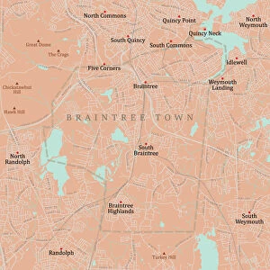
Braintree Essex UK City Street Map

![]()
Wall Art and Photo Gifts from Fine Art Storehouse
Braintree Essex UK City Street Map
Vector Illustration of a City Street Map of Braintree, Essex, UK. Included files are EPS (v10) and Hi-Res JPG.
Data courtesy from Ordnance Survey: VectorMap District
https:/ordnancesurvey.co.uk/business-and-government/products/vectormap-district.html
OS OpenData is free to use under the Open Government Licence (OGL).
Contains OS data eCrown copyright and database right 2017.
http:/nationalarchives.gov.uk/doc/open-government-licence/version/3/
Unleash your creativity and transform your space into a visual masterpiece!
Frank Ramspott
Media ID 15055191
© Frank Ramspott, all rights reserved
Aerial View Computer Graphic Directly Above Essex Gray Green Road Map Street Map Text Braintree Digitally Generated Image
FEATURES IN THESE COLLECTIONS
> Aerial Photography
> Related Images
> Arts
> Contemporary art
> Digital artwork
> Street art
> Arts
> Portraits
> Pop art gallery
> Street art portraits
> Arts
> Street art graffiti
> Digital art
> Digital paintings
> Arts
> Street art graffiti
> Digital art
> Vector illustrations
> Europe
> United Kingdom
> England
> Essex
> Braintree
> Europe
> United Kingdom
> England
> Essex
> Grays
> Europe
> United Kingdom
> England
> Essex
> Related Images
> Europe
> United Kingdom
> Maps
> Fine Art Storehouse
> Map
> Street Maps
> Maps and Charts
> Related Images
EDITORS COMMENTS
This print showcases a meticulously detailed city street map of Braintree, Essex, UK. Crafted as a vector illustration, this artwork captures the essence of the town's urban landscape with precision and artistry. The inclusion of EPS (v10) and Hi-Res JPG files ensures that this print can be enjoyed in various formats. The accuracy of this map is thanks to Ordnance Survey's VectorMap District data, which lends credibility and authenticity to the piece. With their permission under the Open Government Licence (OGL), OS OpenData has made it possible for us to appreciate this stunning representation. Incorporating elements such as buildings, streets, roads, and text labels, this digitally generated image provides an aerial view directly above Braintree. The color palette consisting of shades of gray, green, blue, and white adds vibrancy while maintaining clarity. Frank Ramspott's masterful design brings together cartography and computer graphics seamlessly in this visually striking composition. By deliberately excluding people from the image itself, he allows viewers to focus solely on exploring the physical geography captured within. Whether you are a resident or simply fascinated by maps and cities alike, this print will undoubtedly captivate your imagination with its intricate details and artistic flair.
MADE IN THE USA
Safe Shipping with 30 Day Money Back Guarantee
FREE PERSONALISATION*
We are proud to offer a range of customisation features including Personalised Captions, Color Filters and Picture Zoom Tools
SECURE PAYMENTS
We happily accept a wide range of payment options so you can pay for the things you need in the way that is most convenient for you
* Options may vary by product and licensing agreement. Zoomed Pictures can be adjusted in the Cart.