Home > Aerial Photography > Related Images
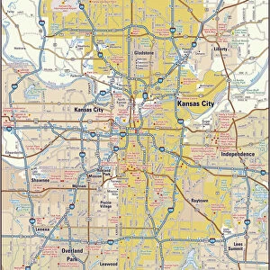
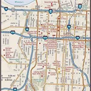
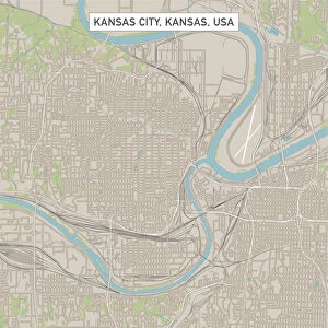
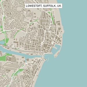
Kansas City Missouri US City Street Map

![]()
Wall Art and Photo Gifts from Fine Art Storehouse
Kansas City Missouri US City Street Map
Vector Illustration of a City Street Map of Kansas City, Missouri, USA. Scale 1:60, 000.
All source data is in the public domain.
U.S. Geological Survey, US Topo
Used Layers:
USGS The National Map: National Hydrography Dataset (NHD)
USGS The National Map: National Transportation Dataset (NTD)
Unleash your creativity and transform your space into a visual masterpiece!
Frank Ramspott
Media ID 15215796
© Frank Ramspott, all rights reserved
Aerial View City Map Computer Graphic Directly Above Downtown District Gray Missouri Road Map Text Digitally Generated Image Green Color Kansas City White Color
FEATURES IN THESE COLLECTIONS
> Aerial Photography
> Related Images
> Animals
> Insects
> Hemiptera
> Green Scale
> Arts
> Contemporary art
> Digital artwork
> Street art
> Arts
> Landscape paintings
> Waterfall and river artworks
> River artworks
> Arts
> Portraits
> Pop art gallery
> Street art portraits
> Arts
> Street art graffiti
> Digital art
> Digital paintings
> Arts
> Street art graffiti
> Digital art
> Vector illustrations
> Fine Art Storehouse
> Map
> Street Maps
> Fine Art Storehouse
> Map
> USA Maps
> Maps and Charts
> Geological Map
> Maps and Charts
> Related Images
> North America
> United States of America
> Kansas
> Kansas City
EDITORS COMMENTS
This print showcases a meticulously detailed city street map of Kansas City, Missouri, USA. With a scale of 1:60,000, every intricate detail is brought to life in this vector illustration. The artist, Frank Ramspott, has skillfully utilized various layers from the USGS The National Map to create this stunning piece. The map encompasses the entire downtown district of Kansas City and highlights its prominent features such as lakes and rivers. Its vibrant colors - gray, blue, white, and green - beautifully depict the physical geography of the area. The aerial view captured directly above adds a unique perspective to this digitally generated image. With no people present in the frame, the focus remains solely on the artistry and craftsmanship behind this visually appealing city street map. It serves as both an informative cartographic tool and an exquisite design element that would enhance any space it graces. It's worth noting that all source data used for creating this artwork is in the public domain courtesy of U. S Geological Survey (USGS) including their National Hydrography Dataset (NHD) and National Transportation Dataset (NTD). This ensures accuracy while also respecting copyright regulations. Overall, Frank Ramspott's creation offers viewers a glimpse into Kansas City's urban landscape through his masterful blend of technology and artistry.
MADE IN THE USA
Safe Shipping with 30 Day Money Back Guarantee
FREE PERSONALISATION*
We are proud to offer a range of customisation features including Personalised Captions, Color Filters and Picture Zoom Tools
SECURE PAYMENTS
We happily accept a wide range of payment options so you can pay for the things you need in the way that is most convenient for you
* Options may vary by product and licensing agreement. Zoomed Pictures can be adjusted in the Cart.