Home > Arts > Street art graffiti > Digital art > Vector illustrations
Ventura California US City Street Map

![]()
Wall Art and Photo Gifts from Fine Art Storehouse
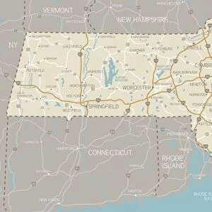
Ventura California US City Street Map
Vector Illustration of a City Street Map of Ventura, California, USA. Scale 1:60, 000.
All source data is in the public domain.
U.S. Geological Survey, US Topo
Used Layers:
USGS The National Map: National Hydrography Dataset (NHD)
USGS The National Map: National Transportation Dataset (NTD)
Unleash your creativity and transform your space into a visual masterpiece!
Frank Ramspott
Media ID 15055057
© Frank Ramspott, all rights reserved
Aerial View California City Map Computer Graphic Directly Above Downtown District Gray Pacific Ocean Road Map Text Digitally Generated Image Green Color Ventura White Color
FEATURES IN THESE COLLECTIONS
> Aerial Photography
> Related Images
> Animals
> Insects
> Hemiptera
> Green Scale
> Animals
> Mammals
> Cricetidae
> California Mouse
> Arts
> Artists
> O
> Oceanic Oceanic
> Arts
> Contemporary art
> Digital artwork
> Street art
> Arts
> Landscape paintings
> Waterfall and river artworks
> River artworks
> Arts
> Portraits
> Pop art gallery
> Street art portraits
> Arts
> Street art graffiti
> Digital art
> Digital paintings
> Arts
> Street art graffiti
> Digital art
> Vector illustrations
> Fine Art Storehouse
> Map
> Street Maps
> Fine Art Storehouse
> Map
> USA Maps
> Maps and Charts
> Geological Map
EDITORS COMMENTS
This print showcases a meticulously detailed city street map of Ventura, California, USA. With a scale of 1:60,000, every intricate feature is beautifully illustrated in this vector illustration. The image encompasses the essence of Ventura with its stunning Pacific Ocean backdrop and the vibrant downtown district nestled alongside it. The map incorporates various layers from reliable sources such as the U. S. Geological Survey's National Hydrography Dataset (NHD) and National Transportation Dataset (NTD). These layers provide accurate representations of the city's hydrography and transportation networks. Designed by Frank Ramspott, this digitally generated image captures Ventura's charm through its depiction of streets, roads, rivers, lakes, and other significant landmarks. The color palette consists of shades of gray for text elements along with green for vegetation areas and blue for water bodies against a clean white background. With no people present in the picture, viewers can focus solely on appreciating the artistry behind this cartographic masterpiece. Its aerial perspective offers a unique vantage point directly above Ventura that allows one to admire its physical geography from an entirely new angle. Perfectly suited for any space or occasion, this visually striking city street map print effortlessly combines design aesthetics with geographic accuracy to create an exquisite piece that celebrates Ventura's rich heritage and urban landscape.
MADE IN THE USA
Safe Shipping with 30 Day Money Back Guarantee
FREE PERSONALISATION*
We are proud to offer a range of customisation features including Personalised Captions, Color Filters and Picture Zoom Tools
SECURE PAYMENTS
We happily accept a wide range of payment options so you can pay for the things you need in the way that is most convenient for you
* Options may vary by product and licensing agreement. Zoomed Pictures can be adjusted in the Cart.