Home > Arts > Landscape paintings > Landscape art > Mountain landscapes
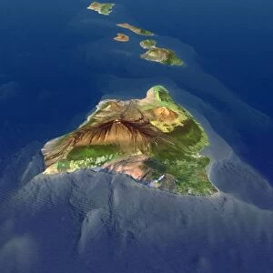
Hawai i, satellite image

![]()
Wall Art and Photo Gifts from Science Photo Library
Hawai i, satellite image
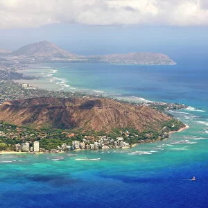
Hawai i, satellite image. Satellite image of the island of Hawai i, also known as Big Island. Vegetation is green, water is blue, and cloud is white. Hawai i is the largest of the Hawaiian islands in the Pacific Ocean. It is made up of five shield volcanos: Kohala (extinct), Mauna Kea (dormant), Hualalai (active), Maua Loa (active), and Kilauea (very actve). Mauna Loa (lower centre left) is the largest volcano on Earth by area and Mauna Kilauea has been erupting since 1983
Science Photo Library features Science and Medical images including photos and illustrations
Media ID 4243073
© PLANETOBSERVER/SCIENCE PHOTO LIBRARY
Archipelago Big Island Cloud Clouds Earth Observation Geological Hawaii Hawaiian Island Kilauea Mauna Kea Mountain Mountainous Mountains North American Pacific Ocean Satellite Satellite Image Us A Volcanic Volcano Volcanoes Volcanology Volcanos Vulcanology Island Of Hawaii Mauna Loa
FEATURES IN THESE COLLECTIONS
> Animals
> Mammals
> Muridae
> Water Mouse
> Arts
> Artists
> O
> Oceanic Oceanic
> Arts
> Contemporary art
> Landscapes
> Mountain landscapes
> Arts
> Landscape paintings
> Landscape art
> Mountain landscapes
> North America
> Related Images
> North America
> United States of America
> USA Heritage Sites
> Hawaii Volcanoes National Park
> Popular Themes
> North Island
> Science Photo Library
> Aerial and Satellite
EDITORS COMMENTS
This print showcases the stunning beauty of Hawaii, captured from a satellite image. The island of Hawaii, also known as Big Island, is depicted in all its glory with lush green vegetation, vibrant blue waters, and fluffy white clouds. Situated in the Pacific Ocean, Hawaii is the largest among the Hawaiian islands and boasts a remarkable geological composition. The island comprises five shield volcanoes: Kohala (extinct), Mauna Kea (dormant), Hualalai (active), Mauna Loa (active but lower centre left) - Earth's largest volcano by area - and Kilauea (very active). Notably, Kilauea has been continuously erupting since 1983, adding to the dynamic nature of this volcanic archipelago. This mesmerizing image not only highlights the geographical features but also offers insights into Hawai'i's rich volcanic history. It serves as a testament to both the power and fragility of our planet's natural wonders. As we gaze upon this breathtaking landscape encompassing mountains shrouded in clouds and majestic volcanoes dominating the horizon, we are reminded of Hawaii's unique allure. This satellite image provides us with an awe-inspiring perspective on one of North America's most iconic destinations – an enchanting blend of tropical paradise and geological marvels that continue to shape our understanding of Earth's geology.
MADE IN THE USA
Safe Shipping with 30 Day Money Back Guarantee
FREE PERSONALISATION*
We are proud to offer a range of customisation features including Personalised Captions, Color Filters and Picture Zoom Tools
SECURE PAYMENTS
We happily accept a wide range of payment options so you can pay for the things you need in the way that is most convenient for you
* Options may vary by product and licensing agreement. Zoomed Pictures can be adjusted in the Cart.