Home > North America > United States of America > Colorado > Denver
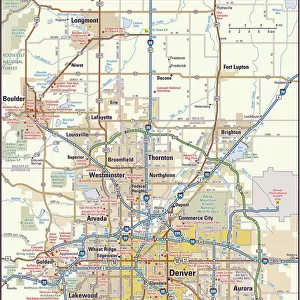
Denver Colorado US City Street Map

![]()
Wall Art and Photo Gifts from Fine Art Storehouse
Denver Colorado US City Street Map
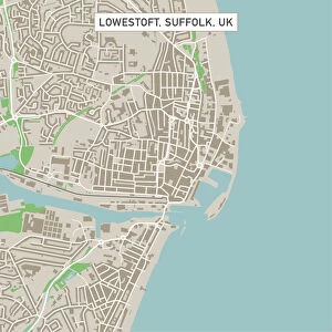
Vector Illustration of a City Street Map of Denver, Colorado, USA. Scale 1:60, 000.
All source data is in the public domain.
U.S. Geological Survey, US Topo
Used Layers:
USGS The National Map: National Hydrography Dataset (NHD)
USGS The National Map: National Transportation Dataset (NTD)
Unleash your creativity and transform your space into a visual masterpiece!
Frank Ramspott
Media ID 15215854
© Frank Ramspott, all rights reserved
Aerial View City Map Colorado Computer Graphic Denver Directly Above Downtown District Gray Road Map Text Digitally Generated Image Green Color White Color
FEATURES IN THESE COLLECTIONS
> Aerial Photography
> Related Images
> Animals
> Insects
> Hemiptera
> Green Scale
> Arts
> Contemporary art
> Digital artwork
> Street art
> Arts
> Landscape paintings
> Waterfall and river artworks
> River artworks
> Arts
> Portraits
> Pop art gallery
> Street art portraits
> Arts
> Street art graffiti
> Digital art
> Digital paintings
> Arts
> Street art graffiti
> Digital art
> Vector illustrations
> Fine Art Storehouse
> Map
> Street Maps
> Fine Art Storehouse
> Map
> USA Maps
> Maps and Charts
> Geological Map
> Maps and Charts
> Related Images
> North America
> United States of America
> Colorado
> Denver
EDITORS COMMENTS
This print showcases a meticulously detailed city street map of Denver, Colorado, USA. With a scale of 1:60,000, every intricate feature is beautifully illustrated in this vector image. The source data used for this artwork is in the public domain and comes from the U. S. Geological Survey's National Map, specifically their National Hydrography Dataset (NHD) and National Transportation Dataset (NTD). The print highlights various landmarks such as the South Platte River, Cooper Lake, and the bustling downtown district of Denver. It provides an aerial view that allows viewers to appreciate the physical geography of the area directly above it. The design incorporates text elements in shades of gray, blue, white, and green to enhance readability. Created by talented artist Frank Ramspott using computer graphics technology, this digitally generated image captures the essence of Denver's vibrant streets without including any people. Its cartographic precision makes it an ideal piece for those interested in urban planning or simply admiring city maps
MADE IN THE USA
Safe Shipping with 30 Day Money Back Guarantee
FREE PERSONALISATION*
We are proud to offer a range of customisation features including Personalised Captions, Color Filters and Picture Zoom Tools
SECURE PAYMENTS
We happily accept a wide range of payment options so you can pay for the things you need in the way that is most convenient for you
* Options may vary by product and licensing agreement. Zoomed Pictures can be adjusted in the Cart.