Home > Europe > United Kingdom > England > London > Sights > Southwark Park
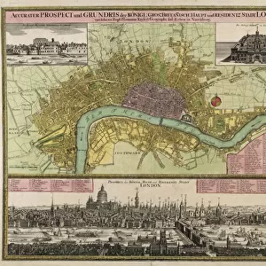
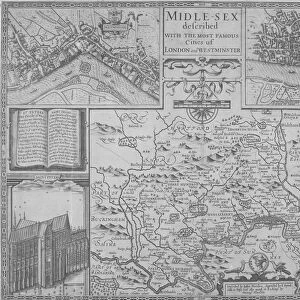
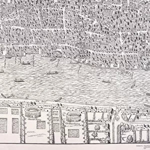
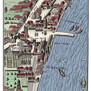
Map of London, 1690

![]()
Wall Art and Photo Gifts from Heritage Images
Map of London, 1690
Map of London, 1690. The upper section shows a map of the City of London, City of Westminster, River Thames, Lambeth and Southwark. The lower section shows a view of Westwood Park, Worcestershire. The heraldic arms of the City of London can be seen on the right
Heritage Images features heritage image collections
Media ID 15175470
© London Metropolitan Archives (City of London) / Heritage-Images
Cartography Coat Of Arms Heraldry Lambeth Map Making Southwark Worcestershire City Of Westminster Westwood Park
FEATURES IN THESE COLLECTIONS
> Arts
> Landscape paintings
> Waterfall and river artworks
> River artworks
> Europe
> United Kingdom
> England
> London
> Boroughs
> City of London
> Europe
> United Kingdom
> England
> London
> Boroughs
> City of Westminster
> Europe
> United Kingdom
> England
> London
> Boroughs
> Lambeth
> Europe
> United Kingdom
> England
> London
> Boroughs
> Southwark
> Europe
> United Kingdom
> England
> London
> Museums
> British Library
> Europe
> United Kingdom
> England
> London
> River Thames
> Europe
> United Kingdom
> England
> London
> Sights
> Southwark Park
> Europe
> United Kingdom
> England
> London
> Towns
> Lambeth
> Europe
> United Kingdom
> England
> Maps
EDITORS COMMENTS
This print showcases a remarkable piece of history - the Map of London from 1690. The upper section of the map provides an intricate depiction of the City of London, City of Westminster, River Thames, Lambeth, and Southwark. Every street and landmark is meticulously illustrated, offering a glimpse into the bustling metropolis during that era. Intriguingly, the lower section presents a stunning view of Westwood Park in Worcestershire. This serene landscape transports us to another time and place, contrasting with the vibrant cityscape above. Notably, on the right side of this extraordinary map lies the heraldic arms representing the prestigious City of London. These symbols embody centuries-old traditions and values that have shaped England's capital city. The anonymous cartographer responsible for this masterpiece skillfully captured every geographical feature with meticulous detail through engraving techniques prevalent in seventeenth-century Britain. Preserved by Guildhall Library and Art Gallery, this invaluable artifact offers valuable insights into English geography and map-making practices during that period. As we delve into this rich tapestry woven by history itself, let us appreciate how maps like these serve as windows to our past – guiding us through time while preserving our cultural heritage for generations to come.
MADE IN THE USA
Safe Shipping with 30 Day Money Back Guarantee
FREE PERSONALISATION*
We are proud to offer a range of customisation features including Personalised Captions, Color Filters and Picture Zoom Tools
SECURE PAYMENTS
We happily accept a wide range of payment options so you can pay for the things you need in the way that is most convenient for you
* Options may vary by product and licensing agreement. Zoomed Pictures can be adjusted in the Cart.