Home > Europe > United Kingdom > England > London > Art > Venues > St Pauls Church
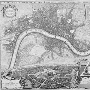
Maps of London, 1610

![]()
Wall Art and Photo Gifts from Heritage Images
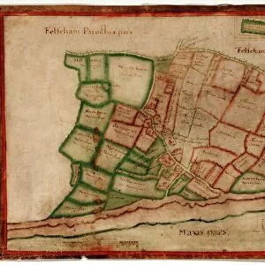
Maps of London, 1610
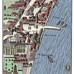
Maps of London, 1610. The upper left section shows the City of Westminster and River Thames. The upper right section shows the City of London and River Thames. The central section shows a map of Greater London and surrounding counties. The panels in the bottom corners show Westminster Abbey (left) and the old St Pauls Cathedral (right)
Heritage Images features heritage image collections
Media ID 15175468
© London Metropolitan Archives (City of London) / Heritage-Images
Abbey Cartography Map Making Pauls Cathedral Speed St Pauls Cathedral Westminster Abbey City Of Westminster John Speed Norden
FEATURES IN THESE COLLECTIONS
> Architecture
> Country
> England
> Arts
> Artists
> N
> John Norden
> Arts
> Artists
> S
> John Speed
> Europe
> United Kingdom
> England
> Greater London
> Related Images
> Europe
> United Kingdom
> England
> London
> Art
> Venues
> St Pauls Church
> Europe
> United Kingdom
> England
> London
> Boroughs
> City of London
> Europe
> United Kingdom
> England
> London
> Boroughs
> City of Westminster
> Europe
> United Kingdom
> England
> London
> Museums
> British Library
EDITORS COMMENTS
This print showcases the intricate and detailed Maps of London from 1610. Divided into three sections, it offers a fascinating glimpse into the city's past. The upper left section presents the City of Westminster and River Thames, capturing the essence of this historic area with its majestic architecture and flowing river. On the upper right, we are transported to the bustling City of London, where towering buildings line the banks of the Thames. The central section reveals a map encompassing Greater London and its surrounding counties, providing an invaluable resource for understanding the geographical layout during that era. In each bottom corner panel, we are treated to iconic landmarks - on the left is Westminster Abbey, exuding centuries-old grandeur with its Gothic spires reaching towards the sky; while on the right stands St Paul's Cathedral in all its glory as one of London's most prominent religious sites. This remarkable engraving by anonymous artists captures not only cartographic accuracy but also showcases Britain's rich architectural heritage. It serves as a testament to John Speed and John Norden's contributions to map-making during this period. With its blend of artistry and historical significance, this print transports us back in time to seventeenth-century London—a vibrant city steeped in religion, culture, commerce, and innovation along both sides of River Thames.
MADE IN THE USA
Safe Shipping with 30 Day Money Back Guarantee
FREE PERSONALISATION*
We are proud to offer a range of customisation features including Personalised Captions, Color Filters and Picture Zoom Tools
SECURE PAYMENTS
We happily accept a wide range of payment options so you can pay for the things you need in the way that is most convenient for you
* Options may vary by product and licensing agreement. Zoomed Pictures can be adjusted in the Cart.