Home > Europe > United Kingdom > England > Herefordshire > Maps
Highly detailed vector map of England

![]()
Wall Art and Photo Gifts from Fine Art Storehouse
Highly detailed vector map of England
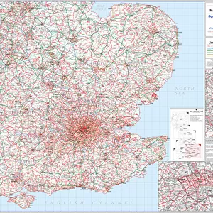
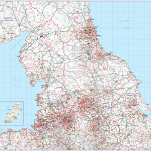
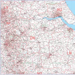
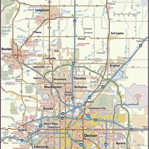
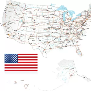
Highly detailed vector map of England. Source data courtesy of NGDC and NASA. Source database: World Data Bank II. The source data is in the public domain. Data updated and improved. File was created on July 27, 2011
Unleash your creativity and transform your space into a visual masterpiece!
Media ID 32146018
Birmingham England Clip Art Close Up Computer Graphic Devon Direction Green Colour Isle Of Wight Kent England Latitude Leicester Liverpool England London England Longitude Manchester England Merseyside Multi Coloured Newcastle Upon Tyne Square Composition Text Vector Western Script Digitally Generated Image Dorset England Herefordshire Sheffield Somerset England
FEATURES IN THESE COLLECTIONS
> Animals
> Mammals
> Muridae
> Western Mouse
> Arts
> Photorealistic artworks
> Detailed art pieces
> Masterful detailing in art
> Arts
> Street art graffiti
> Digital art
> Digital paintings
> Arts
> Street art graffiti
> Digital art
> Vector illustrations
> Europe
> United Kingdom
> England
> Birmingham
> Related Images
> Europe
> United Kingdom
> England
> Devon
> Related Images
> Europe
> United Kingdom
> England
> Dorset
> Related Images
> Europe
> United Kingdom
> England
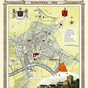
> Herefordshire
> Maps
> Europe
> United Kingdom
> England
> Herefordshire
> Related Images
> Europe
> United Kingdom
> England
> Kent
> Related Images
> Fine Art Storehouse
> Map
> Reference Maps
EDITORS COMMENTS
This highly detailed vector map of England is a captivating piece that showcases the beauty and intricacies of this historic country. The vibrant colors and precise lines bring to life the diverse regions, from Manchester to London, Birmingham to Newcastle upon Tyne. Created using source data courtesy of NGDC and NASA, this print offers a unique perspective on England's physical geography. With latitude and longitude markings, it allows viewers to explore every corner with ease. The close-up view highlights key areas such as Isle of Wight, Herefordshire, Kent, Somerset, Dorset, Liverpool, Leicester, Norwich, Sheffield - all beautifully illustrated in multi-colored splendor. Digitally generated with expert precision and attention to detail by Fine Art Storehouse artists on July 27th 2011; this artwork continues to be updated and improved over time. It is a testament to their dedication in creating visually stunning representations of our world. The absence of people in the image adds an air of tranquility while emphasizing the focus on England's natural beauty. This square composition serves as both an informative tool for navigation enthusiasts or simply as an eye-catching piece for art lovers
MADE IN THE USA
Safe Shipping with 30 Day Money Back Guarantee
FREE PERSONALISATION*
We are proud to offer a range of customisation features including Personalised Captions, Color Filters and Picture Zoom Tools
SECURE PAYMENTS
We happily accept a wide range of payment options so you can pay for the things you need in the way that is most convenient for you
* Options may vary by product and licensing agreement. Zoomed Pictures can be adjusted in the Cart.