Home > Arts > Street art graffiti > Digital art > Vector illustrations
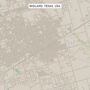
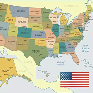
Thousand Oaks California US City Street Map

![]()
Wall Art and Photo Gifts from Fine Art Storehouse
Thousand Oaks California US City Street Map
Vector Illustration of a City Street Map of Thousand Oaks, California, USA. Scale 1:60, 000.
All source data is in the public domain.
U.S. Geological Survey, US Topo
Used Layers:
USGS The National Map: National Hydrography Dataset (NHD)
USGS The National Map: National Transportation Dataset (NTD)
Unleash your creativity and transform your space into a visual masterpiece!
Frank Ramspott
Media ID 15055081
© Frank Ramspott, all rights reserved
Aerial View California City Map Computer Graphic Directly Above Downtown District Gray Road Map Text Digitally Generated Image Green Color White Color
FEATURES IN THESE COLLECTIONS
> Aerial Photography
> Related Images
> Animals
> Insects
> Hemiptera
> Green Scale
> Animals
> Mammals
> Cricetidae
> California Mouse
> Arts
> Contemporary art
> Digital artwork
> Street art
> Arts
> Landscape paintings
> Waterfall and river artworks
> River artworks
> Arts
> Portraits
> Pop art gallery
> Street art portraits
> Arts
> Street art graffiti
> Digital art
> Digital paintings
> Arts
> Street art graffiti
> Digital art
> Vector illustrations
> Fine Art Storehouse
> Map
> Street Maps
> Fine Art Storehouse
> Map
> USA Maps
> Maps and Charts
> Geological Map
> Maps and Charts
> Related Images
EDITORS COMMENTS
This vibrant and detailed print showcases the captivating city street map of Thousand Oaks, California, USA. With a scale of 1:60,000, every intricate detail is brought to life in this vector illustration. The artist, Frank Ramspott, skillfully combines cartography and design to create a visually stunning piece. The map encompasses various notable landmarks such as Lake Sherwood, Los Virgenes Reservoir, Westlake Lake, and the downtown district. It also highlights the presence of a river flowing through the city. The roads are meticulously depicted with clear markings and labels for easy navigation. Rendered in shades of gray and green with touches of blue and white text accents against a colorful backdrop, this digitally generated image captures the essence of Thousand Oaks' physical geography from an aerial perspective directly above. Its inclusion of no people allows viewers to focus solely on appreciating the artistry behind this cartographic masterpiece. It is important to note that all source data used in creating this artwork is in the public domain courtesy of U. S Geological Survey's National Hydrography Dataset (NHD) and National Transportation Dataset (NTD). This ensures accuracy while adhering to copyright regulations. Whether you're a resident or simply fascinated by maps and urban landscapes, this print will undoubtedly add sophistication and intrigue to any space it graces.
MADE IN THE USA
Safe Shipping with 30 Day Money Back Guarantee
FREE PERSONALISATION*
We are proud to offer a range of customisation features including Personalised Captions, Color Filters and Picture Zoom Tools
SECURE PAYMENTS
We happily accept a wide range of payment options so you can pay for the things you need in the way that is most convenient for you
* Options may vary by product and licensing agreement. Zoomed Pictures can be adjusted in the Cart.