Home > Europe > United Kingdom > England > Maps
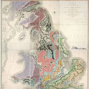
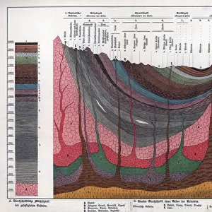
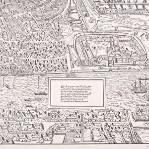
Geological Map of the Site of London, 1908

![]()
Wall Art and Photo Gifts from Heritage Images
Geological Map of the Site of London, 1908
Geological Map of the Site of London, 1908. From Early London - Prehistoric, Roman, Saxon and Norman, by Sir Walter Besant. [Adam & Charles Black, London, 1908]
Heritage Images features heritage image collections
Media ID 15467231
© The Print Collector / Heritage-Images
A C Black Adam Charles Adam Charles Black Besant Cartography Early London Prehistoric Geological Map Map Making Saxon And Norman Sir Walter Sir Walter Besant Walter Walter Besant Western Script
FEATURES IN THESE COLLECTIONS
> Arts
> Artists
> R
> Roman Roman
> Arts
> Artists
> W
> Charles White
> Arts
> Minimalist artwork
> Monochrome artwork
> Fine art
> Arts
> Minimalist artwork
> Monochrome artwork
> Monochrome paintings
> Europe
> United Kingdom
> England
> Maps
> Maps and Charts
> Early Maps
> Maps and Charts
> Geological Map
> Maps and Charts
> Related Images
EDITORS COMMENTS
This print showcases the "Geological Map of the Site of London, 1908" taken from Sir Walter Besant's book "Early London - Prehistoric, Roman, Saxon and Norman". Published by Adam & Charles Black in London, this map offers a fascinating glimpse into the geological history of one of the world's most iconic cities. The intricate cartography reveals the various layers that make up London's foundation, providing valuable insights into its ancient past. From prehistoric times to Roman occupation and subsequent Saxon and Norman influences, this map traces centuries of human habitation on this historic site. Sir Walter Besant's meticulous attention to detail is evident in every line and text on this monochrome masterpiece. The Western script used adds an air of elegance to the overall composition. As we delve into each section of this geological marvel, we are transported through time as if walking alongside our ancestors who once roamed these very streets. This print serves as a reminder that beneath the bustling metropolis lies a rich tapestry woven by nature itself. It invites us to appreciate not only London's architectural wonders but also its deep-rooted connection with geology and geography. As we gaze upon this remarkable piece of artistry, let us be reminded that maps are not merely tools for navigation but gateways to understanding our heritage and connecting with our roots.
MADE IN THE USA
Safe Shipping with 30 Day Money Back Guarantee
FREE PERSONALISATION*
We are proud to offer a range of customisation features including Personalised Captions, Color Filters and Picture Zoom Tools
SECURE PAYMENTS
We happily accept a wide range of payment options so you can pay for the things you need in the way that is most convenient for you
* Options may vary by product and licensing agreement. Zoomed Pictures can be adjusted in the Cart.