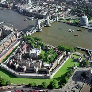
Home > Europe > United Kingdom > England > London > Sights > Tower of London
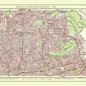
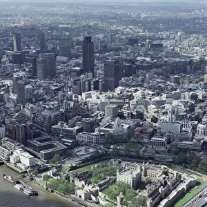
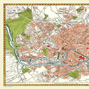
Old Street Map of London Central, East End and River Thames 1908

![]()
Wall Art and Photo Gifts from MapSeeker
Old Street Map of London Central, East End and River Thames 1908
Detailed colour Street Plan of London from 1908. The street map features London Central and the east End with the River Thames from Blackfriars Bridge to the London Docks. The plan also shows the Tower of London
Welcome to the Mapseeker Image library and enter an historic gateway to one of the largest on-line collections of Historic Maps, Nostalgic Views, Vista's and Panorama's from a World gone by.
Media ID 20347612
© Mapseeker Publishing Ltd, Collins Bartholomew Ltd
London Street Plan Map Of Central London Old London Street Map Old Map Of London Central Street Plan Blackfriars Bridge London Docks Tower Of London
FEATURES IN THESE COLLECTIONS
> Architecture
> Bridges
> Tower Bridge
> Architecture
> Towers
> Tower Bridge
> Architecture
> Towers
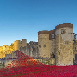
> Tower of London
> Arts
> Photorealistic artworks
> Detailed art pieces
> Masterful detailing in art
> Europe
> United Kingdom
> England
> London
> River Thames
> Europe
> United Kingdom
> England
> London
> Sights
> Tower Bridge
> Europe
> United Kingdom
> England
> London
> Sights
> Tower of London
> Maps and Charts
> Related Images
> MapSeeker
> British Town And City Plans
> English & Welsh PORTFOLIO
> Popular Themes
> Tower of London
EDITORS COMMENTS
This stunning print captures a piece of history with its detailed color street plan of London from 1908. The old street map showcases the bustling heart of the city, including London Central and the East End, along with the majestic River Thames stretching from Blackfriars Bridge to the iconic London Docks. Every intricate detail is meticulously depicted, allowing viewers to step back in time and explore the streets as they were over a century ago. One notable feature on this vintage map is none other than the historic Tower of London, standing tall amidst its surroundings. Its imposing presence serves as a reminder of centuries past and adds an air of grandeur to this already captivating scene. The inclusion of key landmarks such as Blackfriars Bridge and various docks along the Thames further enhances our understanding of how vital these areas were for trade and transportation during that era. It's fascinating to see how much has changed since then, yet some elements remain constant. This print by John Bartholomew, published by Collins BartholomewMapseeker Publishing, offers not only a glimpse into London's rich history but also serves as a testament to human ingenuity in creating such intricate maps long before modern technology came into play. Whether you're an avid historian or simply appreciate beautiful artwork, this old street map will undoubtedly captivate your imagination and transport you back in time through its vibrant colors and meticulous details.
MADE IN THE USA
Safe Shipping with 30 Day Money Back Guarantee
FREE PERSONALISATION*
We are proud to offer a range of customisation features including Personalised Captions, Color Filters and Picture Zoom Tools
SECURE PAYMENTS
We happily accept a wide range of payment options so you can pay for the things you need in the way that is most convenient for you
* Options may vary by product and licensing agreement. Zoomed Pictures can be adjusted in the Cart.