Home > Arts > Street art graffiti > Digital art > Vector illustrations
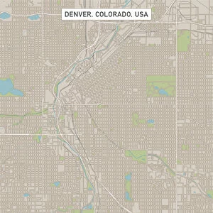
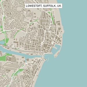
San Francisco California US City Street Map

![]()
Wall Art and Photo Gifts from Fine Art Storehouse
San Francisco California US City Street Map
Vector Illustration of a City Street Map of San Francisco, California, USA. Scale 1:60, 000.
All source data is in the public domain.
U.S. Geological Survey, US Topo
Used Layers:
USGS The National Map: National Hydrography Dataset (NHD)
USGS The National Map: National Transportation Dataset (NTD)
Unleash your creativity and transform your space into a visual masterpiece!
Frank Ramspott
Media ID 15054947
© Frank Ramspott, all rights reserved
Aerial View Blue Color California Computer Graphic Directly Above Downtown Gray Color Road Map San Francisco San Francisco Bay Street Map Text Digitally Generated Image Green Color White Color
FEATURES IN THESE COLLECTIONS
> Aerial Photography
> Related Images
> Animals
> Insects
> Hemiptera
> Green Scale
> Animals
> Mammals
> Cricetidae
> California Mouse
> Arts
> Contemporary art
> Digital artwork
> Street art
> Arts
> Landscape paintings
> Waterfall and river artworks
> River artworks
> Arts
> Portraits
> Pop art gallery
> Street art portraits
> Arts
> Street art graffiti
> Digital art
> Digital paintings
> Arts
> Street art graffiti
> Digital art
> Vector illustrations
> Fine Art Storehouse
> Map
> Street Maps
> Fine Art Storehouse
> Map
> USA Maps
> Maps and Charts
> Geological Map
> Maps and Charts
> Related Images
EDITORS COMMENTS
This print showcases a meticulously detailed city street map of the vibrant and iconic San Francisco, California. Created as a vector illustration, this artwork beautifully captures the essence of this bustling metropolis. The scale of 1:60,000 ensures that every intricate detail is accurately represented. The source data used for this masterpiece is in the public domain, courtesy of the U. S. Geological Survey's National Map project. The layers utilized include the National Hydrography Dataset (NHD) and the National Transportation Dataset (NTD), providing an extensive depiction of San Francisco's hydrological features and transportation infrastructure. From its world-renowned bay to its dynamic downtown area, this visually striking image encompasses it all – rivers, lakes, buildings, streets – everything that defines San Francisco's unique charm. The expertly crafted cartography design brings together various elements into one cohesive digitally generated image. With no people present in the picture, attention is solely focused on appreciating the artistry behind this stunning representation of physical geography. Aerial view perspective from directly above allows viewers to immerse themselves in every corner of this magnificent cityscape. The color palette chosen adds depth and clarity to each element depicted - gray for roads and streets, green for parks and open spaces, blue for water bodies such as rivers or lakes - all set against a clean white background. This remarkable piece by Frank Ramspott serves as both an exquisite work of art and a functional tool for navigation through San Francisco's enchanting urban landscape.
MADE IN THE USA
Safe Shipping with 30 Day Money Back Guarantee
FREE PERSONALISATION*
We are proud to offer a range of customisation features including Personalised Captions, Color Filters and Picture Zoom Tools
SECURE PAYMENTS
We happily accept a wide range of payment options so you can pay for the things you need in the way that is most convenient for you
* Options may vary by product and licensing agreement. Zoomed Pictures can be adjusted in the Cart.