Home > Europe > United Kingdom > England > London > Royalty
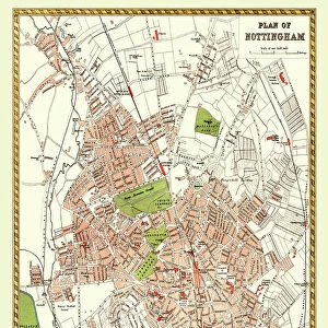
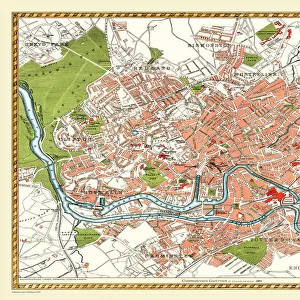
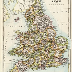
Old Map of Nottingham 1898 from the Royal Atlas by Bartholomew

![]()
Wall Art and Photo Gifts from MapSeeker
Old Map of Nottingham 1898 from the Royal Atlas by Bartholomew
A fine very detailed plan of the City of Nottingham remastered from an original contained within " The Royal Atlas of England and Wales" ; edited by J.G. Bartholomew, published by George Newnes, Limited, London
Welcome to the Mapseeker Image library and enter an historic gateway to one of the largest on-line collections of Historic Maps, Nostalgic Views, Vista's and Panorama's from a World gone by.
Media ID 20347779
Bartholomew Bartholomew Map Historic Map Old Town Plan Royal Atlas Royal Atlas Map Nottingham
FEATURES IN THESE COLLECTIONS
> Arts
> Photorealistic artworks
> Detailed art pieces
> Masterful detailing in art
> Europe
> United Kingdom
> England
> London
> Royalty
> Europe
> United Kingdom
> England
> Maps
> Europe
> United Kingdom
> England
> Nottingham
> Europe
> United Kingdom
> Wales
> Maps
> Europe
> United Kingdom
> Wales
> Posters
> Maps and Charts
> Related Images
> Maps and Charts
> Wales
> MapSeeker
> British Town And City Plans
> English & Welsh PORTFOLIO
EDITORS COMMENTS
This print showcases an exquisite piece of history - the "Old Map of Nottingham 1898" from the renowned Royal Atlas by Bartholomew. Immerse yourself in the rich heritage and intricate details of this fine plan, meticulously remastered from an original found within "The Royal Atlas of England and Wales". Published by George Newnes, Limited in London, this map offers a fascinating glimpse into the City of Nottingham during its bygone era. As you explore this old town plan, every street and landmark comes to life with remarkable precision. From bustling city squares to winding alleyways, each corner holds secrets waiting to be discovered. This historic Nottingham map is a treasure trove for history enthusiasts and avid explorers alike. Transport yourself back in time as you trace the footsteps of those who once walked these streets. Imagine horse-drawn carriages traversing through cobblestone lanes or locals gathering at charming marketplaces. The intricacy captured within this royal atlas map is truly awe-inspiring. Whether you have a personal connection to Nottingham or simply appreciate historical cartography, this print will transport you on a journey through time. Display it proudly in your home or office as a testament to the enduring allure of maps and their ability to connect us with our past
MADE IN THE USA
Safe Shipping with 30 Day Money Back Guarantee
FREE PERSONALISATION*
We are proud to offer a range of customisation features including Personalised Captions, Color Filters and Picture Zoom Tools
SECURE PAYMENTS
We happily accept a wide range of payment options so you can pay for the things you need in the way that is most convenient for you
* Options may vary by product and licensing agreement. Zoomed Pictures can be adjusted in the Cart.