Home > Arts > Artists > I > Irish School Irish School
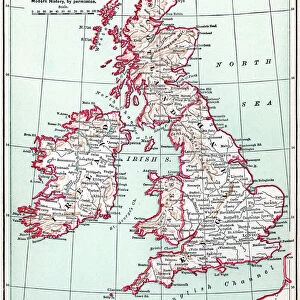
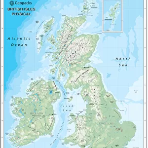
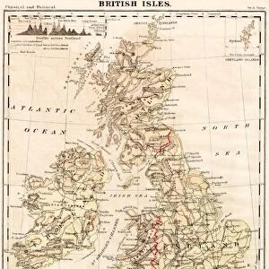
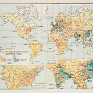
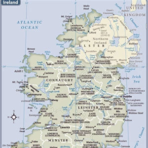
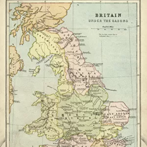
Map of the British Isles 1895

![]()
Wall Art and Photo Gifts from Fine Art Storehouse
Map of the British Isles 1895
The Rand-McNally Grammar School Geography 1895 - Chicago & New York
Unleash your creativity and transform your space into a visual masterpiece!
THEPALMER
Media ID 14824609
© This content is subject to copyright
Great Britain Ireland Scotland Wales
FEATURES IN THESE COLLECTIONS
> Arts
> Artists
> I
> Irish School Irish School
> Europe
> Republic of Ireland
> Maps
> Europe
> United Kingdom
> Maps
> Europe
> United Kingdom
> Scotland
> Maps
> Europe
> United Kingdom
> Scotland
> Posters
> Europe
> United Kingdom
> Scotland
> Related Images
> Europe
> United Kingdom
> Wales
> Maps
> Europe
> United Kingdom
> Wales
> Posters
> Europe
> United Kingdom
> Wales
> Related Images
> Fine Art Storehouse
> Map
> Historical Maps
EDITORS COMMENTS
In this print titled "Map of the British Isles 1895" we are transported back in time to a bygone era, where cartography was an art form and exploration held the promise of endless discovery. This exquisite piece, part of "The Rand-McNally Grammar School Geography 1895" collection, takes us on a visual journey through Europe's enchanting realm known as the British Isles. With meticulous detail and precision, THEPALMER has captured the essence of this historical map. The viewer is immediately drawn to Great Britain's intricate coastline, tracing its contours from Cornwall to Scotland. Ireland lies gracefully beside it, with its lush green landscapes beckoning adventurers to explore every corner. As our eyes wander across the map's surface, we encounter Wales' majestic mountains and valleys that have witnessed centuries of rich history. Scotland reveals itself with its rugged terrain and iconic lochs that whisper tales of ancient clans and mythical creatures. This stunning artwork serves not only as a testament to human curiosity but also as a reminder of how geography shapes our understanding of the world. It invites us to reflect upon our place within these lands while igniting our imagination for future journeys yet untaken. "The Map of the British Isles 1895" is more than just an image; it encapsulates a moment frozen in time when maps were cherished treasures guiding explorers towards new horizons. With THEPALMER's skillful touch, this print becomes both an homage to history and an invitation for us all to
MADE IN THE USA
Safe Shipping with 30 Day Money Back Guarantee
FREE PERSONALISATION*
We are proud to offer a range of customisation features including Personalised Captions, Color Filters and Picture Zoom Tools
SECURE PAYMENTS
We happily accept a wide range of payment options so you can pay for the things you need in the way that is most convenient for you
* Options may vary by product and licensing agreement. Zoomed Pictures can be adjusted in the Cart.