Home > South America > Ecuador > Maps
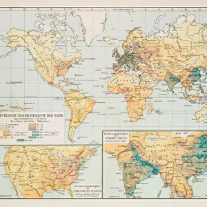
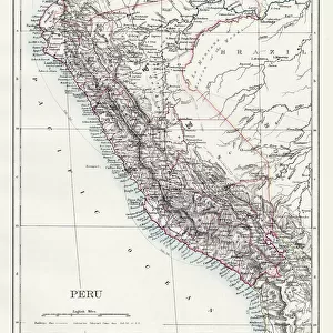
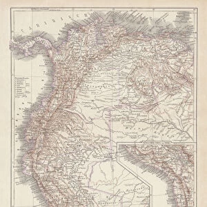
Map of Peru, Colombia, Venezuela, Ecuador 1900

![]()
Wall Art and Photo Gifts from Fine Art Storehouse
Map of Peru, Colombia, Venezuela, Ecuador 1900
Meyers hand-Atlas Leipzig und Wien Verlag des Bibliographischen Instituts 1900
Unleash your creativity and transform your space into a visual masterpiece!
THEPALMER
Media ID 18106883
© 2014 Roberto Adrian Photography
FEATURES IN THESE COLLECTIONS
> Fine Art Storehouse
> Map
> Historical Maps
> South America
> Colombia
> Maps
> South America
> Colombia
> Related Images
> South America
> Ecuador
> Maps
> South America
> Ecuador
> Related Images
> South America
> Peru
> Maps
> South America
> Peru
> Related Images
> South America
> Venezuela
> Maps
> South America
> Venezuela
> Related Images
EDITORS COMMENTS
In this print titled "Map of Peru, Colombia, Venezuela, Ecuador 1900" we are transported back in time to the turn of the century. The intricate details and vibrant colors of this vintage map immediately catch our attention. Created by THEPALMER and sourced from Fine Art Storehouse, it is a true testament to the beauty and artistry found in cartography. This particular map showcases four South American countries: Peru, Colombia, Venezuela, and Ecuador. As we explore its contours and boundaries, we can't help but marvel at how these nations have evolved over time. It serves as a visual reminder of their rich history and cultural heritage. The craftsmanship evident in this print is remarkable; every line meticulously drawn with precision. The choice of warm hues adds an air of nostalgia to the piece while simultaneously highlighting the diverse landscapes that make up these countries – from lush rainforests to towering mountain ranges. As we gaze upon this stunning artwork, we are reminded not only of its historical significance but also its ability to spark curiosity about distant lands. It invites us on a journey through time and space – an opportunity to delve into the past while contemplating our place within a larger world. Whether displayed in a classroom or adorning the walls of an avid traveler's home, "Map of Peru, Colombia, Venezuela, Ecuador 1900" offers both aesthetic appeal and educational value for all who encounter it.
MADE IN THE USA
Safe Shipping with 30 Day Money Back Guarantee
FREE PERSONALISATION*
We are proud to offer a range of customisation features including Personalised Captions, Color Filters and Picture Zoom Tools
SECURE PAYMENTS
We happily accept a wide range of payment options so you can pay for the things you need in the way that is most convenient for you
* Options may vary by product and licensing agreement. Zoomed Pictures can be adjusted in the Cart.