Home > Animals > Fishes > C > Coley
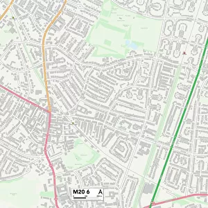
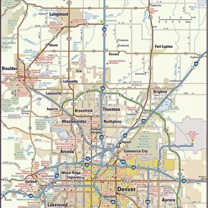
CT Fairfield Weston Vector Road Map

![]()
Wall Art and Photo Gifts from Fine Art Storehouse
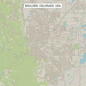
CT Fairfield Weston Vector Road Map
CT Fairfield Weston Vector Road Map. All source data is in the public domain. U.S. Census Bureau Census Tiger. Used Layers: areawater, linearwater, roads, rails, cousub, pointlm, uac10
Unleash your creativity and transform your space into a visual masterpiece!
Frank Ramspott
Media ID 20688195
© Frank Ramspott, all rights reserved
City Map Computer Graphic Connecticut County Digital Composite District Fairfield Geographical Border Georgetown Road Map Text Vector Digitally Generated Image Weston Wilton
FEATURES IN THESE COLLECTIONS
> Animals
> Fishes
> C
> Coley
> Animals
> Mammals
> Cats (Wild)
> Tiger
> Animals
> Mammals
> Muridae
> Plains Mouse
> Animals
> Mammals
> Muridae
> Water Mouse
> Arts
> Contemporary art
> Digital artwork
> Pop art
> Arts
> Contemporary art
> Digital artwork
> Street art
> Arts
> Contemporary art
> Pop art
> Digital art
> Arts
> Landscape paintings
> Waterfall and river artworks
> River artworks
> Arts
> Still life artwork
> Pop art
> Digital art
> Arts
> Modern art pieces
> Pop art
> Street art
> Fine Art Storehouse
> Map
> Reference Maps
EDITORS COMMENTS
This print showcases the intricate details of the CT Fairfield Weston Vector Road Map. Created by talented artist Frank Ramspott, this digitally generated image is a testament to his exceptional cartography skills. Using various layers such as areawater, linearwater, roads, rails, cousub, pointlm, and uac10 sourced from the public domain U. S. Census Bureau Census Tiger data, Ramspott has beautifully crafted a visually stunning representation of Connecticut's Fairfield and Weston counties. The vibrant colors and precise vector lines bring life to this city map that highlights geographical borders with utmost accuracy. From bustling cities to serene towns like Lyons Plain and Cannondale, every location is meticulously depicted on this map. The inclusion of rivers like Saugatuck River and lakes adds an element of natural beauty to the composition. This digital composite serves not only as a functional road map but also as an exquisite piece of art suitable for any space. With no people present in the image itself, it allows viewers to focus solely on its remarkable design and physical geography. Whether you're a resident or visitor exploring these regions or simply appreciate fine cartographic work, this print will undoubtedly enhance your surroundings with its detailed depiction of Fairfield and Weston's diverse landscapes.
MADE IN THE USA
Safe Shipping with 30 Day Money Back Guarantee
FREE PERSONALISATION*
We are proud to offer a range of customisation features including Personalised Captions, Color Filters and Picture Zoom Tools
SECURE PAYMENTS
We happily accept a wide range of payment options so you can pay for the things you need in the way that is most convenient for you
* Options may vary by product and licensing agreement. Zoomed Pictures can be adjusted in the Cart.