Home > Arts > Artists > C > Abraham Cresques
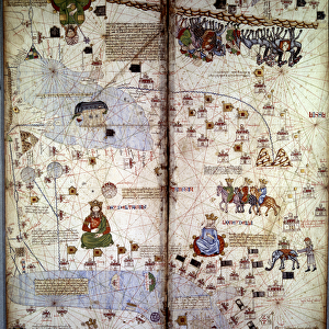
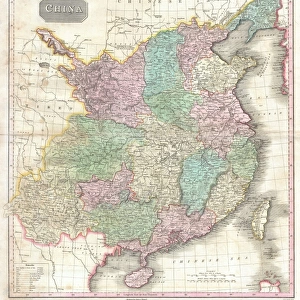
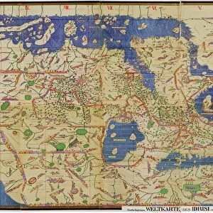
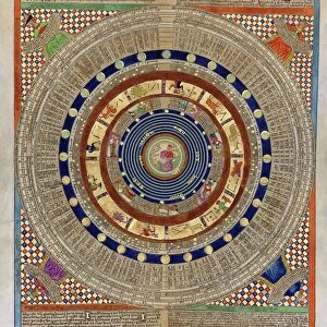
Geographic map: China, Ganges Valley, Sumatra, Ceylan. Catalan Atlas (Catalan map) (Spain
 (Spain")
![]()
Wall Art and Photo Gifts from Fine Art Finder
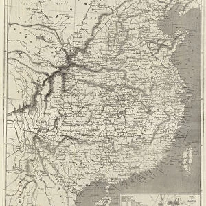
Geographic map: China, Ganges Valley, Sumatra, Ceylan. Catalan Atlas (Catalan map) (Spain
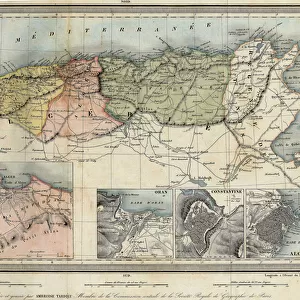
JLJ4686532 Geographic map: China, Ganges Valley, Sumatra, Ceylan. Catalan Atlas (Catalan map) (Spain). Manuscript of 1375 (Folio 2v - folio 3) by Abraham Cresques. BN, Paris by Unknown Artist, (14th century); Bibliotheque Nationale, Paris, France; (add.info.: Geographic map: China, Ganges Valley, Sumatra, Ceylan. Catalan Atlas (Catalan map) (Spain). Manuscript of 1375 (Folio 2v - folio 3) by Abraham Cresques. BN, Paris); Photo ePhoto Josse; out of copyright
Media ID 23717636
© Josse / Bridgeman Images
FEATURES IN THESE COLLECTIONS
> Arts
> Artists
> C
> Abraham Cresques
> Asia
> Related Images
> Europe
> France
> Paris
> Maps
> Europe
> France
> Paris
> Related Images
> Europe
> Spain
> Related Images
> Fine Art Finder
> Artists
> Greek
> Fine Art Finder
> Artists
> Unknown Artist
EDITORS COMMENTS
This print showcases a remarkable piece of history - the Catalan Atlas, created by Abraham Cresques in 1375. The map spans across China, the Ganges Valley, Sumatra, and Ceylan (now known as Sri Lanka), offering a glimpse into the geographical knowledge of that era. The intricate details and vibrant colors of this manuscript are truly awe-inspiring. It is evident that great skill and artistry went into its creation. The map not only serves as a navigational tool but also reflects the cultural exchange between Europe and Asia during the Middle Ages. As we examine this ancient cartographic masterpiece, we can imagine how it must have fascinated explorers and scholars alike. Its depiction of distant lands would have sparked curiosity about far-off civilizations and their unique landscapes. Preserved within the Bibliotheque Nationale in Paris, France, this photograph allows us to appreciate both the historical significance and artistic beauty of the Catalan Atlas. Through its delicate brushstrokes and meticulous attention to detail, it transports us back in time to an era when maps were hand-drawn with precision and care. Whether you are an enthusiast of Asian art or simply intrigued by medieval geography, this print offers a window into our past. It reminds us of humanity's enduring quest for knowledge about our world - a pursuit that continues to shape our understanding today.
MADE IN THE USA
Safe Shipping with 30 Day Money Back Guarantee
FREE PERSONALISATION*
We are proud to offer a range of customisation features including Personalised Captions, Color Filters and Picture Zoom Tools
SECURE PAYMENTS
We happily accept a wide range of payment options so you can pay for the things you need in the way that is most convenient for you
* Options may vary by product and licensing agreement. Zoomed Pictures can be adjusted in the Cart.