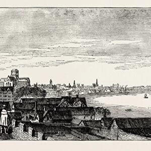
Sea chart of the southeastern part of the Aegean Sea, print maker: Jan Luyken, Johannes

![]()
Wall Art and Photo Gifts from Liszt Collection
Sea chart of the southeastern part of the Aegean Sea, print maker: Jan Luyken, Johannes
Sea chart of the southeastern part of the Aegean Sea, print maker: Jan Luyken, Johannes van Keulen I, unknown, 1682 - 1803
Liszt Collection of nineteenth-century engravings and images to browse and enjoy
Media ID 12716233
© Quint Lox Limited
1682 1803 Address Bargaining Carpet City Compass Compass Rose French Miles Harbor Inset Jan Luyken Johannes Van Keulen Negotiations North Port Rhodes Rose Sea Chart South Eastern Tortoises Turban Turtles Aegean Aegean Sea Southeastern
EDITORS COMMENTS
This print showcases a remarkable sea chart of the southeastern part of the Aegean Sea, created by renowned print makers Jan Luyken and Johannes van Keulen I. Dating back to an unknown time between 1682 and 1803, this exquisite piece combines elements of artistry and cartography. The intricate details within the map draw our attention, revealing various geographical features such as ports, cities, and even an inset harbor in Rhodes. A compass rose elegantly adorns the top right corner, guiding sailors through their maritime journeys. Intriguingly, amidst this rich tapestry of geographic information lies a scene depicting negotiations taking place between two individuals. One man wearing a turban sits opposite another adorned with a hat while they engage in bargaining over what appears to be a carpet. This unexpected inclusion adds depth to the artwork by providing insight into cultural exchanges that may have occurred during voyages across these seas. Tortoises and turtles are scattered throughout the composition, symbolizing longevity and wisdom associated with seafaring endeavors. The presence of French miles further emphasizes the international nature of navigation during this era. Quint Lox's skillful capture allows us to appreciate not only the historical significance but also the artistic beauty embedded within this sea chart. As we gaze upon it, we are transported back in time to an age when exploration was at its peak - where land met sea on maps that were both practical tools for navigation and works of art meant to inspire wonder about our vast
MADE IN THE USA
Safe Shipping with 30 Day Money Back Guarantee
FREE PERSONALISATION*
We are proud to offer a range of customisation features including Personalised Captions, Color Filters and Picture Zoom Tools
SECURE PAYMENTS
We happily accept a wide range of payment options so you can pay for the things you need in the way that is most convenient for you
* Options may vary by product and licensing agreement. Zoomed Pictures can be adjusted in the Cart.


![[Giant Redwood, Santa Cruz]](/sq/694/giant-redwood-santa-cruz-12650726.jpg.webp)