Home > Europe > United Kingdom > England > Herefordshire > Maps
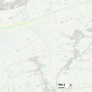
Sefton PR9 7 Map

![]()
Wall Art and Photo Gifts from Map Marketing
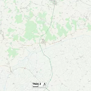
Sefton PR9 7 Map
Postcode Sector Map of Sefton PR9 7
Media ID 19976776
Beaconsfield Road Beech Grove Beresford Drive Beresford Gardens Bispham Road Bright Street Brooke Close Byrom Street Canning Road Carisbrooke Drive Chester Avenue Chester Road Church Close Churchgate Churchtown Cobden Road Denmark Road Derwent Avenue Devonshire Road Farm Close Fosters Close Gladstone Road Grove Park Hawthorne Grove Henley Drive Hereford Road Heysham Road High Park Lawson Street Little Lane Manor Road Mill Lane Milton Street Montgomery Avenue Montrose Drive Moss Lane Newton Street Norwood Avenue Norwood Crescent Old Park Lane Palmerston Road Parkside Place Pitt Street Rectory Road Roe Lane Rookery Road Rosebery Street Russell Avenue Russell Road Salisbury Street Scott Street Sefton Sidney Road St Cuthberts Road Tedder Avenue The Grange Thornton Road Vernon Road Victory Avenue Warren Road Wavell Close
FEATURES IN THESE COLLECTIONS
> Europe
> Denmark
> Related Images
> Europe
> United Kingdom
> England
> Herefordshire
> Maps
> Europe
> United Kingdom
> Scotland
> Angus
> Montrose
> Europe
> United Kingdom
> Wales
> Powys
> Montgomery
> Map Marketing
> Postcode Sector Maps
> PR - Preston
> Maps and Charts
> Related Images
MADE IN THE USA
Safe Shipping with 30 Day Money Back Guarantee
FREE PERSONALISATION*
We are proud to offer a range of customisation features including Personalised Captions, Color Filters and Picture Zoom Tools
SECURE PAYMENTS
We happily accept a wide range of payment options so you can pay for the things you need in the way that is most convenient for you
* Options may vary by product and licensing agreement. Zoomed Pictures can be adjusted in the Cart.