Home > Europe > United Kingdom > England > Cambridgeshire > The Green
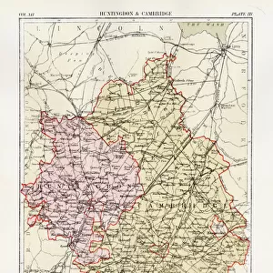
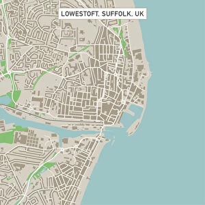
Cambridge Cambridgeshire UK City Street Map

![]()
Wall Art and Photo Gifts from Fine Art Storehouse
Cambridge Cambridgeshire UK City Street Map
Vector Illustration of a City Street Map of Cambridge, Cambridgeshire, UK. Included files are EPS (v10) and Hi-Res JPG.
Data courtesy from Ordnance Survey: VectorMap District
https:/ordnancesurvey.co.uk/business-and-government/products/vectormap-district.html
OS OpenData is free to use under the Open Government Licence (OGL).
Contains OS data eCrown copyright and database right 2017.
http:/nationalarchives.gov.uk/doc/open-government-licence/version/3/
Unleash your creativity and transform your space into a visual masterpiece!
Frank Ramspott
Media ID 15055255
© Frank Ramspott, all rights reserved
Aerial View Cambridgeshire Computer Graphic Directly Above Gray Green Road Map Street Map Text Cambridge Digitally Generated Image River Cam
FEATURES IN THESE COLLECTIONS
> Aerial Photography
> Related Images
> Arts
> Contemporary art
> Digital artwork
> Street art
> Arts
> Landscape paintings
> Waterfall and river artworks
> River artworks
> Arts
> Portraits
> Pop art gallery
> Street art portraits
> Arts
> Street art graffiti
> Digital art
> Digital paintings
> Arts
> Street art graffiti
> Digital art
> Vector illustrations
> Europe
> United Kingdom
> England
> Cambridgeshire
> Cam
> Europe
> United Kingdom
> England
> Cambridgeshire
> Cambridge
> Europe
> United Kingdom
> England
> Cambridgeshire
> The Green
> Europe
> United Kingdom
> England
> Cambridgeshire
> Related Images
> Fine Art Storehouse
> Map
> Street Maps
EDITORS COMMENTS
This print showcases a meticulously detailed vector illustration of the charming city streets of Cambridge, Cambridgeshire in the United Kingdom. Created by talented artist Frank Ramspott, this artwork captures the essence and beauty of this historic city. The map includes essential files such as EPS (v10) and Hi-Res JPG, allowing for versatile usage and high-quality reproduction. The data used to create this masterpiece is courtesy of Ordnance Survey: VectorMap District, a trusted source renowned for its accuracy. Highlighted in shades of gray, green, blue, and white, this digitally generated image provides an aerial view directly above Cambridge. It encompasses various elements that make up the city's identity - from iconic buildings to bustling streets - all intricately depicted with precision. With no people present in the image itself, it allows viewers to focus solely on exploring every intricate detail presented within this stunning piece of cartography. This visually striking composition not only serves as a decorative piece but also offers an opportunity for individuals to immerse themselves in the physical geography and rich history that Cambridge has to offer.
MADE IN THE USA
Safe Shipping with 30 Day Money Back Guarantee
FREE PERSONALISATION*
We are proud to offer a range of customisation features including Personalised Captions, Color Filters and Picture Zoom Tools
SECURE PAYMENTS
We happily accept a wide range of payment options so you can pay for the things you need in the way that is most convenient for you
* Options may vary by product and licensing agreement. Zoomed Pictures can be adjusted in the Cart.