Home > Europe > United Kingdom > England > Norfolk > Norwich
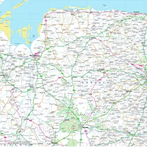
Norwich Norfolk UK City Street Map

![]()
Wall Art and Photo Gifts from Fine Art Storehouse
Norwich Norfolk UK City Street Map
Vector Illustration of a City Street Map of Norwich, Norfolk, UK. Included files are EPS (v10) and Hi-Res JPG.
Data courtesy from Ordnance Survey: VectorMap District
https:/ordnancesurvey.co.uk/business-and-government/products/vectormap-district.html
OS OpenData is free to use under the Open Government Licence (OGL).
Contains OS data eCrown copyright and database right 2017.
http:/nationalarchives.gov.uk/doc/open-government-licence/version/3/
Unleash your creativity and transform your space into a visual masterpiece!
Frank Ramspott
Media ID 15055279
© Frank Ramspott, all rights reserved
Aerial View Computer Graphic Directly Above Gray Green Norfolk Road Map Street Map Text Digitally Generated Image Norwich River Wensum
FEATURES IN THESE COLLECTIONS
> Aerial Photography
> Related Images
> Arts
> Contemporary art
> Digital artwork
> Street art
> Arts
> Landscape paintings
> Waterfall and river artworks
> River artworks
> Arts
> Portraits
> Pop art gallery
> Street art portraits
> Arts
> Street art graffiti
> Digital art
> Digital paintings
> Arts
> Street art graffiti
> Digital art
> Vector illustrations
> Europe
> United Kingdom
> England
> Norfolk
> Norwich
> Europe
> United Kingdom
> England
> Norfolk
> Related Images
> Europe
> United Kingdom
> Maps
> Fine Art Storehouse
> Map
> Street Maps
> Maps and Charts
> Related Images
EDITORS COMMENTS
This print showcases a meticulously detailed vector illustration of the charming city street map of Norwich, Norfolk, UK. With its vibrant colors and intricate design, this artwork truly captures the essence of this historic city. The inclusion of files in EPS (v10) and Hi-Res JPG formats ensures versatility and high-quality reproduction. The data used to create this stunning piece is courtesy of Ordnance Survey: VectorMap District, a trusted source for accurate mapping information. This reliable resource guarantees that every road, building, river (including River Wensum), and street is accurately depicted. Created using advanced digital technology, this visually striking image offers an aerial view directly above Norwich. Its computer-generated graphics beautifully highlight the physical geography of the area while maintaining a sense of authenticity. With no people present in the scene, viewers can fully immerse themselves in exploring every corner of this intricately designed map. The combination of gray streets against a backdrop of green parks and blue rivers creates a harmonious color palette that adds depth to the overall composition. Whether you are an admirer of cartography or simply appreciate fine art prints with historical significance, this remarkable creation by Frank Ramspott is sure to captivate your imagination.
MADE IN THE USA
Safe Shipping with 30 Day Money Back Guarantee
FREE PERSONALISATION*
We are proud to offer a range of customisation features including Personalised Captions, Color Filters and Picture Zoom Tools
SECURE PAYMENTS
We happily accept a wide range of payment options so you can pay for the things you need in the way that is most convenient for you
* Options may vary by product and licensing agreement. Zoomed Pictures can be adjusted in the Cart.