Home > Arts > Artists > R > Edmund Russell
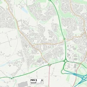
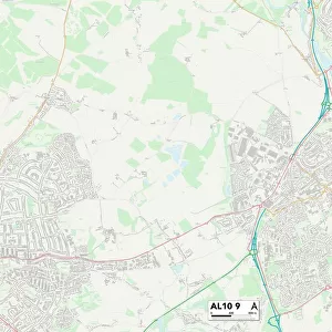
St Albans AL3 5 Map

![]()
Wall Art and Photo Gifts from Map Marketing
St Albans AL3 5 Map
Postcode Sector Map of St Albans AL3 5
Media ID 19965148
Adelaide Street Ashwell Street Beech Place Beech Road Bernard Street Bridle Close Cannon Street Carlisle Avenue Catherine Street Century Close Christchurch Close Church Crescent Church Street Connaught Road Cricketers Close Cross Street Dalton Street Dickens Close Drovers Way Folly Lane Grange Street Heath Avenue High Grove Kimberley Road Ladysmith Road Langley Crescent Links View Little Acre Margaret Avenue Market Place Marshall Avenue May Close Neville Close Normandy Road Russell Avenue Selby Avenue Seymour Road Spencer Street Spinney Lane St Albans St Bernards Road Tanners Close Thornton Street Townsend Waddington Road Watson Avenue Waverley Road Wells Close West View Road
FEATURES IN THESE COLLECTIONS
> Animals
> Mammals
> Muridae
> Heath Mouse
> Arts
> Artists
> R
> Edmund Russell
> Map Marketing
> Postcode Sector Maps
> AL - St Albans
> Maps and Charts
> Related Images
MADE IN THE USA
Safe Shipping with 30 Day Money Back Guarantee
FREE PERSONALISATION*
We are proud to offer a range of customisation features including Personalised Captions, Color Filters and Picture Zoom Tools
SECURE PAYMENTS
We happily accept a wide range of payment options so you can pay for the things you need in the way that is most convenient for you
* Options may vary by product and licensing agreement. Zoomed Pictures can be adjusted in the Cart.