Home > Europe > United Kingdom > England > Bristol > Clifton
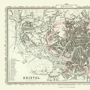
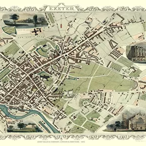
Old Map of Bristol 1851 by John Tallis

![]()
Wall Art and Photo Gifts from MapSeeker
Old Map of Bristol 1851 by John Tallis
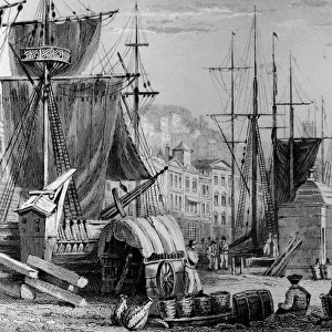
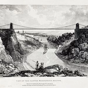
This 1851 John Tallis map of Bristol shows the new course of the River Avon and the Floating Harbour. At Clifton Down the famous suspension bridge is yet to be constructed, but clearly marked as Proposed Suspension Bridge, it was officially opened over a decade later in 1864. The illustrations are of Clifton Down from Rownham Ferry, south side of Bristol Cathedral, Clifton Observatory, High Cross Green, Redcliff Church and a busy scene across Broad Quay Bristol
Welcome to the Mapseeker Image library and enter an historic gateway to one of the largest on-line collections of Historic Maps, Nostalgic Views, Vista's and Panorama's from a World gone by.
Media ID 20347959
Historic Map John Tallis John Tallis Map Old Town Plan Tallis Map Bristol Bristol City
FEATURES IN THESE COLLECTIONS
> Architecture
> Bridges
> Clifton Suspension Bridge
> Arts
> Artists
> T
> John Tallis
> Europe
> United Kingdom
> England
> Avon
> Europe
> United Kingdom
> England
> Bristol
> Bristol
> Europe
> United Kingdom
> England
> Bristol
> Clifton
> Europe
> United Kingdom
> Wales
> Ceredigion
> New Quay
> Historic
> Medieval architecture
> Cathedrals and churches
> Church history
> Maps and Charts
> Related Images
> MapSeeker
> British Town And City Plans
> English & Welsh PORTFOLIO
EDITORS COMMENTS
This print showcases the "Old Map of Bristol 1851" by John Tallis, offering a glimpse into the city's rich history. The map depicts Bristol during a transformative period, highlighting significant changes in its landscape and infrastructure. One notable feature is the altered course of the River Avon and the Floating Harbour, reflecting efforts to improve navigation and trade within the city. While exploring this vintage map, one can observe several fascinating illustrations that bring key landmarks to life. Clifton Down captures attention with its absence of the iconic suspension bridge we know today; instead, it is labeled as a proposed project that would later become an emblematic symbol of Bristol's identity when it opened in 1864. Other illustrations include scenic views from Rownham Ferry overlooking Clifton Down, the majestic south side of Bristol Cathedral, Clifton Observatory providing panoramic vistas over the cityscape, High Cross Green bustling with activity, Redcliff Church standing tall against time's passage, and a vibrant scene across Broad Quay showcasing Bristol's thriving commerce. As we delve into this historic treasure trove capturing Bristol's past glory through intricate details and meticulous cartography by John Tallis himself, we are transported back to an era where progress was shaping this remarkable city. This old town plan serves as a testament to both our fascination with history and our appreciation for how far Bristol has come since then.
MADE IN THE USA
Safe Shipping with 30 Day Money Back Guarantee
FREE PERSONALISATION*
We are proud to offer a range of customisation features including Personalised Captions, Color Filters and Picture Zoom Tools
SECURE PAYMENTS
We happily accept a wide range of payment options so you can pay for the things you need in the way that is most convenient for you
* Options may vary by product and licensing agreement. Zoomed Pictures can be adjusted in the Cart.