Home > Maps and Charts > Willem Janszoon Blaeu
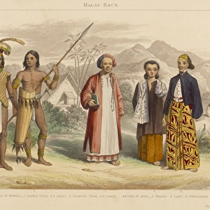
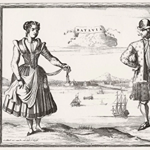
Atlas Novus. Asia. People of Java, 17th c

![]()
Wall Art and Photo Gifts from Mary Evans Picture Library
Atlas Novus. Asia. People of Java, 17th c
BLAEU, Jan (1596-1673). Atlas Novus or Atlas Maior. 1635 - 1665. Asia noviter delineata. Map of Asia printed in Amsterdam circa 1635. Detail depicting Java inhabitants. Etching. SPAIN. CATALONIA. Barcelona. Biblioteca de Catalunya (National Library of Catalonia)
Mary Evans Picture Library makes available wonderful images created for people to enjoy over the centuries
Media ID 14179314
© Iberfoto/Mary Evans
1571 1596 1635 1638 1665 1673 Amsterdam Atlas Barcelona Biblioteca Blaeu Catalonia Catalunya Couples Delineata Depicting Engravings Etching Etchings Ethnographic Inhabitants Janszoon Java Maior Monde Noviter Novus Upright Willem Persons
EDITORS COMMENTS
This detail is taken from the Atlas Novus, or Atlas Maior, a seminal work of cartography created by the renowned Flemish cartographer Jan Blaeu between 1635 and 1665. The map, which was printed in Amsterdam, offers a fresh perspective of Asia, meticulously updated from earlier maps. In this particular section, the focus shifts from geographical features to the human inhabitants of Java, an island in Southeast Asia. The image showcases a lively scene of Java people engaged in various activities. A couple is depicted in the foreground, with the man wearing a headdress adorned with feathers and the woman carrying a child on her back. Several other figures can be seen in the background, some working in the fields while others are engaged in social activities. The intricate etching style brings the scene to life, capturing the essence of the Java community in the 17th century. The Atlas Novus was a groundbreaking work in its time, as it incorporated the latest geographical discoveries and ethnographic information. It was produced during the height of the Dutch colonial period in Asia, with significant contributions from other cartographers such as Willem Janszoon and William Blaeu. The map was later acquired by the Biblioteca de Catalunya (National Library of Catalonia) in Barcelona, Spain, and remains an invaluable resource for scholars and historians today. This vertical, upright, color print offers a unique glimpse into the lives of the people of Java during a pivotal period in world history. The intricate etchings and detailed depictions serve as a testament to the skill and dedication of the cartographers who created this masterpiece.
MADE IN THE USA
Safe Shipping with 30 Day Money Back Guarantee
FREE PERSONALISATION*
We are proud to offer a range of customisation features including Personalised Captions, Color Filters and Picture Zoom Tools
SECURE PAYMENTS
We happily accept a wide range of payment options so you can pay for the things you need in the way that is most convenient for you
* Options may vary by product and licensing agreement. Zoomed Pictures can be adjusted in the Cart.