Home > Europe > United Kingdom > England > London > Transport > Railway
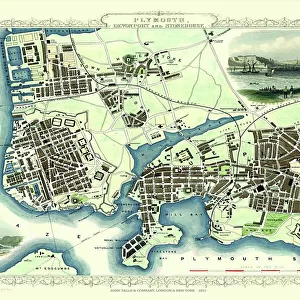
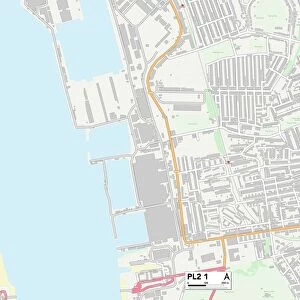
Railway map, Devonport & Plymouth

![]()
Wall Art and Photo Gifts from Mary Evans Picture Library
Railway map, Devonport & Plymouth
Railway map, Devonport & Plymouth, showing the Great Western and London & South Western railways. Date: 1909
Mary Evans Picture Library makes available wonderful images created for people to enjoy over the centuries
Media ID 23144174
© Mary Evans / Pharcide
Devonport Dock Docks Export Junction Junctions Lines Links Maps Plymouth Railways Wharf
FEATURES IN THESE COLLECTIONS
> Animals
> Mammals
> Muridae
> Water Mouse
> Animals
> Mammals
> Muridae
> Western Mouse
> Europe
> France
> Canton
> Landes
> Europe
> United Kingdom
> England
> London
> Related Images
> Europe
> United Kingdom
> England
> London
> Transport
> Railway
> Maps and Charts
> Related Images
> Mary Evans Prints Online
> New Images August 2021
> Popular Themes
> Railway Posters
EDITORS COMMENTS
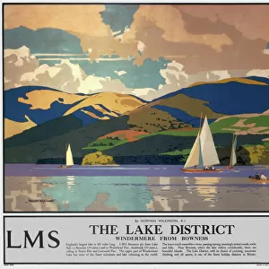
Step back in time with this railway map of Devonport and Plymouth from the year 1909. This intricately detailed map showcases the extensive railway network connecting the bustling ports of Devonport and Plymouth during the Edwardian era. The map highlights the significant role of the railways in linking the land and sea, with the Great Western Railway and the London & South Western Railways prominently featured. The map reveals the strategic locations of various railway junctions, including those at Devonport, Plymstock, and Cattewater, which facilitated the smooth transfer of passengers and goods between trains and ships. The railways played a crucial role in the import and export industries, enabling the efficient movement of goods from the docks to various destinations across the country. The map also illustrates the intricate relationship between the railways and the waterfront, with numerous wharves and docks shown along the coastline. The Cattewater Harbour, a major hub for maritime activity, is clearly marked, further emphasizing the importance of the railways in facilitating the seamless transfer of cargo between ships and trains. This map offers a fascinating glimpse into the transportation infrastructure of Devonport and Plymouth during the early 20th century, providing valuable insights into the intricate web of connections that linked the region to the rest of the country.
MADE IN THE USA
Safe Shipping with 30 Day Money Back Guarantee
FREE PERSONALISATION*
We are proud to offer a range of customisation features including Personalised Captions, Color Filters and Picture Zoom Tools
SECURE PAYMENTS
We happily accept a wide range of payment options so you can pay for the things you need in the way that is most convenient for you
* Options may vary by product and licensing agreement. Zoomed Pictures can be adjusted in the Cart.