Home > Arts > Artists > W > Wilson Wilson
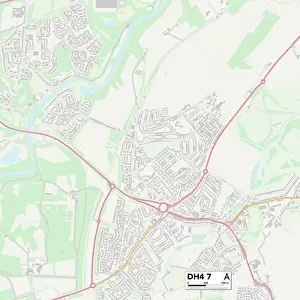
County Durham DH6 4 Map

![]()
Wall Art and Photo Gifts from Map Marketing
County Durham DH6 4 Map
Postcode Sector Map of County Durham DH6 4
Media ID 19968355
Applegarth Ashbourne Drive Belgrave Avenue Belgrave Court Bridge Road Browns Close Church Street Clarence Street County Durham Dene View Earls Way Foundry Close Front Street Grange Crescent Green Crescent Hazel Avenue Lime Close Linden Grove Meadow Close Oakwood Park Avenue Park Hill Pelham Court Prospect Place Sandgate School Avenue Station Road Station Road East Sycamore Close The Avenue The Cedars The Grove The Paddock Willow Court Wilson Close Woodland Crescent Mulberry
FEATURES IN THESE COLLECTIONS
> Arts
> Artists
> W
> Wilson Wilson
> Europe
> United Kingdom
> England
> County Durham
> Durham
> Europe
> United Kingdom
> England
> Durham
> Cornforth
> Europe
> United Kingdom
> England
> Durham
> Durham
> Europe
> United Kingdom
> England
> Durham
> Foxton
> Europe
> United Kingdom
> England
> Durham
> Grange Villa
> Europe
> United Kingdom
> England
> Durham
> High Grange
> Europe
> United Kingdom
> England
> Durham
> Morley
> Europe
> United Kingdom
> England
> Durham
> Quarrington Hill
> Europe
> United Kingdom
> England
> Durham
> Station Town
> Map Marketing
> Postcode Sector Maps
> DH - Durham
> Map Marketing
> UK Maps
MADE IN THE USA
Safe Shipping with 30 Day Money Back Guarantee
FREE PERSONALISATION*
We are proud to offer a range of customisation features including Personalised Captions, Color Filters and Picture Zoom Tools
SECURE PAYMENTS
We happily accept a wide range of payment options so you can pay for the things you need in the way that is most convenient for you
* Options may vary by product and licensing agreement. Zoomed Pictures can be adjusted in the Cart.