Home > Europe > United Kingdom > England > London > Sights > Whitehall
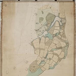
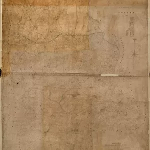
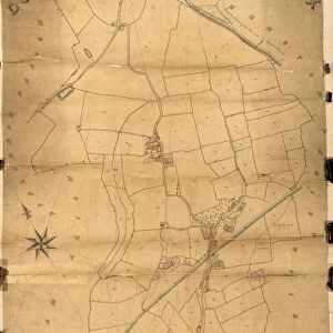
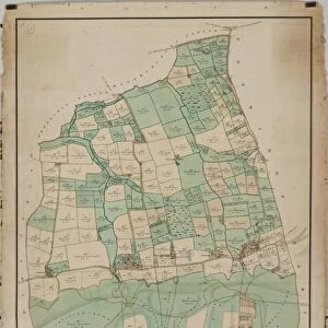
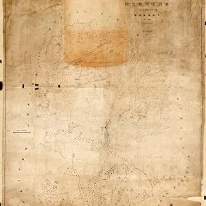
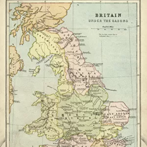
Funtington tithe map, 1838 - 1839

![]()
Wall Art and Photo Gifts from West Sussex County Council
Funtington tithe map, 1838 - 1839
Copied from the Inclosure Award Map by Messrs. Driver, Whitehall [torn away], London; Revised and Corrected to the Present Time for the Commutation of the Tithes of the Parish of Funtington by J. Butler, Chichester. 10 in. to 1 m. 35 × 36
Tithe Award Map Collection
West Sussex Record Office Ref No: TD/W60
West Sussex County Council Record Office contains a fascinating history of the county of West Sussex, England
Media ID 10716333
© West Sussex County Council - All Rights Reserved
1830s 19th Century Historical Mapping South Of England
FEATURES IN THESE COLLECTIONS
> Europe
> United Kingdom
> England
> Chichester
> Europe
> United Kingdom
> England
> London
> Sights
> Whitehall
> Europe
> United Kingdom
> England
> Maps
> Europe
> United Kingdom
> England
> Sussex
> Chichester
> Europe
> United Kingdom
> England
> Sussex
> Funtington
> Europe
> United Kingdom
> England
> Sussex
> Related Images
> Europe
> United Kingdom
> England
> West Sussex
> Chichester
> Europe
> United Kingdom
> England
> West Sussex
> Related Images
> Maps and Charts
> Early Maps
> Maps and Charts
> Related Images
> West Sussex County Council
> West Sussex Record Office
> Tithe Award Maps, 1808-1859
EDITORS COMMENTS
This print showcases the Funtington tithe map, dating back to 1838-1839. The map itself is a copy of the Inclosure Award Map created by Messrs. Driver, Whitehall [torn away], London. However, it has been revised and corrected up until the present time by J. Butler from Chichester for the purpose of commutation of tithes in the Parish of Funtington. Measuring at a scale of 10 inches to 1 mile (35 × 36), this historical mapping artifact provides a fascinating glimpse into the past. Preserved within West Sussex Record Office's Tithe Award Map Collection under reference number TD/W60, it offers valuable insights into land ownership and usage during the early 19th century in southern England. The intricate details depicted on this map highlight not only its historical significance but also its importance as a resource for researchers and historians alike. It serves as a testament to meticulous cartography skills employed during that era. It is worth noting that this particular print does not pertain to any commercial use or affiliation with any company; rather, it stands as an invaluable piece of history preserved by West Sussex County Council. Through such artifacts, we can appreciate how our landscapes have evolved over time while gaining deeper insights into our cultural heritage and local communities' development throughout centuries gone by.
MADE IN THE USA
Safe Shipping with 30 Day Money Back Guarantee
FREE PERSONALISATION*
We are proud to offer a range of customisation features including Personalised Captions, Color Filters and Picture Zoom Tools
SECURE PAYMENTS
We happily accept a wide range of payment options so you can pay for the things you need in the way that is most convenient for you
* Options may vary by product and licensing agreement. Zoomed Pictures can be adjusted in the Cart.